
|
| Routes: Interstates US Routes State Routes: | Home |
| Routes 480-499 (460-479) Prev (500-519) Next |
Quick Links: Marked Unmarked
Decommissioned |
|
Caroline
Hillsboro
Ridgely Boonsboro Greensboro |
MD 480
· Ridgely Rd, Sixth St, Main St
9.08 mi.; from MD 404 near Hillsboro northeast to MD 313, Greensboro.
Marked east-west. ................... |
480
0.0 MD 4042.5 MD 312* 2.9 MD 776 3.4 MD 312* 8.2 MD 314 9.1 MD 313 |
|
Queen Anne's
Ruthsburg
|
MD 481
· Damsontown Rd
5.13 mi.; from MD 309 north to MD 304, Ruthsburg.
Marked north-south. Skirts the western edge of Tuckahoe State Park. |
481
5.1 MD 3040.0 MD 309 |
|
Carroll
Mexico
Hampstead |
MD 482
· Hampstead-Mexico Rd
5.41 mi.; from MD 27 east to Business MD 30, Hampstead.
Marked east-west. ................... Sections of MD 482: |
482
0.0 MD 270.1 MD 852 0.6 MD 849 4.8 MD 30 5.4 MD 30 Bus |
|
Anne Arundel
Severn
|
MD 483
· was Old Camp Meade Rd, Severn Station Rd
old number for former MD 174 after rail grade crossing elimination
No longer assigned (decommissioned). ................... |
|
|
Charles
Marbury
Pisgah |
MD 484
· was Bicknell Rd
from MD 224 southeast to MD 425
No longer assigned (decommissioned). ................... |
|
|
County
Hillsboro
West Denton |
MD 485
· Saathoff Rd
0.65 mi.; loop south off MD 404
Main line unsigned, only the spur MD 485A (Shady Oak La) marked. MD 485 is a loop on the south side of MD 404, the eastern end near the junction of MD 404 and MD 312. You can see where this was the old 404; cracks along the shoulders reveal the old alignment. The biggest surprise though was at the eastern end, where a single 485 marker appears on a stub that dead ends at a private driveway.
Sections of MD 485: |
485
0.0 MD 4040.6 MD 404 |
|
Dorchester
Vienna
|
MD 486
· (name unknown)
0.06 mi.; exact location unknown
No longer assigned (decommissioned). MD 486 and 487 are mentioned in a 1937 operating budget, but only by their numbers and their location in the town of Vienna. The town was otherwise known as the last 2-lane section along US 50 to be bypassed (now the two sections of MD 731). |
|
|
Dorchester
Vienna
|
MD 487
· (name unknown)
0.27 mi.; exact location unknown
No longer assigned (decommissioned). |
|
|
Charles
La Plata
|
MD 488
· La Plata Rd
6.01 mi.; from MD 6 near La Plata northeast to MD 5
Marked east-west. ................... |
488
0.0 MD 66.0 MD 5 |
|
St. Mary's
|
MD 489
· Park Hall Rd
1.27 mi.; from MD 5 east to MD 235
Marked east-west. Connects MD 5 and 235. Did not appear as a state route until the 1970s. |
489
0.0 MD 51.3 MD 235 |
|
Caroline
Whiteleysburg
|
MD 489
· was Whiteleysburg Rd
~450 feet; from MD 314 east to Delaware border
No longer assigned (decommissioned), route now designated MD 314A. A tiny sliver of Whiteleysburg Rd near the Delaware border. MD 314 forks left and becomes DE 12, the right fork is the former 489. It's now designated unsigned MD 314A.
|
|
|
Harford
Havre de Grace
|
MD 490
· S Union Ave
0.31 mi.; from MD 7 (Revolution St) south to Commerce St
Status: Signed north-south. After decades in the state system in unsigned obscurity, MD 490 is finally signed in Havre de Grace. It's only at the two ends, but the whole route is only five blocks long. |
|
|
Washington
Cascade
Smithsburg |
MD 491
· Raven Rock Rd, Macfee Hill Rd
6.78 mi.; from MD 64 northeast to MD 550.
Marked north-south. ................... |
491
6.8 MD 5506.4 FR-WA Line 4.7 WA-FR Line 0.0 MD 64 |
|
Charles
Grayton
|
MD 491
· was Ironsides Rd
from 6 northeast to end of state maintenance near Baptist Church Rd.
No longer assigned (decommissioned), entire route now part of MD 425. ...................
|
|
|
Prince George's
Seat Pleasant
|
MD 492
· was Maryland Park Dr
DC border southeast to current MD 332
No longer assigned (decommissioned by 1950) MD 492 entered the District near its easternmost tip. In the 1940s, 492 was named 65th St. Another case of road name changes in the DC suburbs.
|
|
|
Queen Anne's
Templeville
Caroline
Templeville
|
MD 492
· was Barclay Rd
old number for part of MD 302 forming Queen Anne's-Caroline Co border
No longer assigned (decommissioned), now part of MD 302. By 1942 this number had been superceded by 302. |
|
|
Baltimore
Middle River
|
MD 493
· was Martin Blvd
from US 40 southeast to MD 150.
No longer assigned, number changed to 700 by 1948. [top of page] |
|
|
Baltimore
Middle River
|
MD 493
· was Orems Rd
from beginning of state maintenance near Middle River bridge east to Eastern Ave.
No longer assigned (decommissioned 1942), number reassigned to Martin Blvd, renumbered 700 by 1948. Near its southeastern end, Martin Blvd (current MD 700) underpasses the Amtrak rail line. Prior to that, Orems Road provided a grade crossing to the west. Martin Blvd was assigned MD 493, and the part of Old Orems Rd was re-numbered 599 (and, opposite the tracks, renamed Baker Rd), while 600 (Old Eastern Ave) and 601 (Harrison Blvd) lie opposite the tracks. By 1948, Martin Blvd was renumbered MD 700, and the 493 number has vanished.
|
|
|
Washington
Fairview
Cearfoss |
MD 494
· Fairview Rd
6.82 mi.; from Pennsylvania border east to MD 63, Cearfoss.
Marked east-west. Becomes PA 75 across the line. MD 494 once ended at MD 57, and it was MD 57 that led to the PA border. On the eastern end, it ends on MD 63 about 100 feet south of the Cearfoss Roundabout (MD 63 and 58). Apparently some plan may have been made (and then killed) to connect 494 to Cearfoss Pike (the part west of the circle is no longer MD 58). A strip of land, which may have been set aside for this connection, is marked for sale through the MDOT real estate group. |
494
0.0 PA 750.0 PA Line 0.8 MD 57 6.8 MD 63 |
|
Montgomery
Prince George's
|
I-495
· Capital Beltway
42.03 mi. in Maryland; from Woodrow Wilson Bridge (DC line)
counterclockwise to American Legion Bridge (VA line).
Marked with inner & outer loops. I-495 has its own page in the Interstate section. |
|
|
Garrett
Grantsville Swanton Deep Creek Lake Deer Park |
MD 495
· Swanton Rd, Bittinger Rd, Yoder St [Grantsville]
23.02 mi.; from MD 135 northeast to US 40 Alternate, Grantsville
Marked north-south. Not likely to be confused with the Capital Beltway, being closer to Pittsburgh than Washington, MD 495 existed well before the Interstate system. This was a fragmented route until around 1948. It offers a second route parallet to US 219 to the Oakland/Deep Creek Lake area, and an interchange with I-68. Sections of MD 495: |
495
23.0 US 40 Alt22.7 I-68 19 0.0 MD 135 |
|
Carroll
|
MD 496
· Bachmans Valley Rd
7.23 mi.; from MD 97 northeast to MD 30
Marked east-west. ................... |
496
0.0 MD 977.2 MD 30 |
|
Calvert
Lusby
Cove Point |
MD 497
· Cove Point Rd
2.68 mi.; from MD 2 east to end of state maintenance
Marked east-west. ................... |
497
0.0 MD 20.3 MD 765Q 2.7 ESM |
|
St. Mary's
Piney Point
|
MD 498
· was Lighthouse Rd
from MD 249 west to road end
No longer assigned (decommissioned). ................... |
|
|
St, Mary's
Maddox
|
MD 499
· was Manor Rd
from MD 238 east to MD 234
No longer assigned (decommissioned).
................... |
|


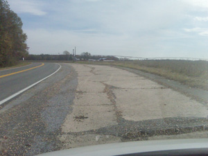
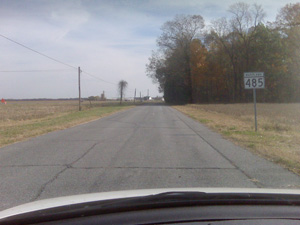 Former dead mans curve on MD 485, and 485 marker on eastern stub. No signage is found on the mainline. (photos 11-07-2010)


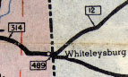 MD 489 shown on a 1948 SRC map.


 MD 491 shown on a 1948 SRC map.

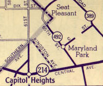 MD 492 shown on a 1952 map. This part of MD 214 is now MD 332. 65th St is now Maryland Park Dr.,
Kingston Ave is now Sultan Ave, 61st St in Maryland is now Capitol Heights Blvd, and C Street is now Crown Street
MD 492 shown on a 1952 map. This part of MD 214 is now MD 332. 65th St is now Maryland Park Dr.,
Kingston Ave is now Sultan Ave, 61st St in Maryland is now Capitol Heights Blvd, and C Street is now Crown Street

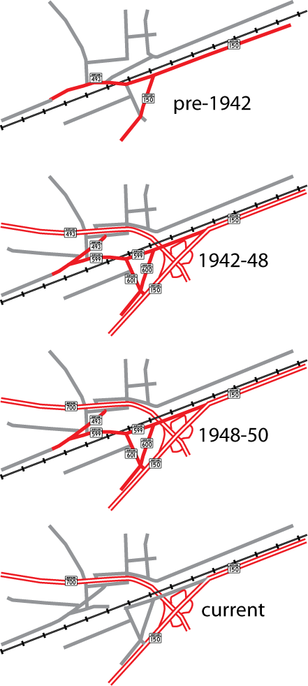 Middle River area routes, showing the two MD 493s.


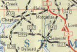 MD 499 shown on a 1955 SRC map. MD 237 is now part of MD 234.