| |
"Now he is somewhere here. Further on, then, a road numbered 23 will go off to his left-no, his right. That goes up and over and back into Pennsylvania but at this place, Shawsville, he can take a little narrow blue road without a number. Then go down a little and over again on 137. There is a ragged curve than that this road makes with 482 and then 31. Rabbit can feel himself swinging up and through that curve into the red line numbered 26 and down into another numbered 340. Red, too; he is really gliding and suddenly sees where he wants to go." - John Updike, Rabbit Run
Maryland is the home of several highway anomalies, including
an intra-county (?!) 2-digit "Interstate," routes that consist of
countless old alignments, and others that begin and end in the middle of nowhere
for no apparent reason. But the system is, if anything, resilient; most highways
carry the same number assigned nearly seventy years ago.
Beginnings of the State Highway System (or at least their numbers)
 The State Roads Commission (predecessor of the current SHA)
came into being on April 30, 1908. Maryland began numbering primary routes
at least as far back as 1927. Although early maps do not show numbering, it is possible for
numbering to have been in use at least internally many years prior. This initial
state numbering appears to have come after the first US highways in 1926, as these route
numbers weren't assigned elsewhere to necessitate a state number change. In addition
to route numbers, Maryland relied upon an extensive place-name based signage
system with guide cities and mileage at every junction. Atop these signs was a
replica of the Ark, shown at left, the ship which along with the Dove
brought Maryland's first settlers to St. Clement's Island (in the Potomac River,
near the end of modern MD 242) on March 25, 1634. There were even billboard-sized
maps of towns as you entered them. The cost of maintenance, and most certainly
World War II, put an end to this practice. Not until 1942 was it required that
every state highway be posted with their numbers. The State Roads Commission (predecessor of the current SHA)
came into being on April 30, 1908. Maryland began numbering primary routes
at least as far back as 1927. Although early maps do not show numbering, it is possible for
numbering to have been in use at least internally many years prior. This initial
state numbering appears to have come after the first US highways in 1926, as these route
numbers weren't assigned elsewhere to necessitate a state number change. In addition
to route numbers, Maryland relied upon an extensive place-name based signage
system with guide cities and mileage at every junction. Atop these signs was a
replica of the Ark, shown at left, the ship which along with the Dove
brought Maryland's first settlers to St. Clement's Island (in the Potomac River,
near the end of modern MD 242) on March 25, 1634. There were even billboard-sized
maps of towns as you entered them. The cost of maintenance, and most certainly
World War II, put an end to this practice. Not until 1942 was it required that
every state highway be posted with their numbers.
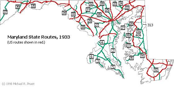
The low numbers from 2-37 were spread statewide, connecting
county seats not otherwise served by a US route. The first objective of the state
road system was to be able to travel from one county seat to another 'without
breaking a spring.' These numbers run in the still familiar pattern - 2 through
6 through Southern Maryland, 12-21 running up the Eastern Shore (swap 33 for 17
and this shows even more), and finally 22-39 running west starting with 22 in
Harford County down to 28 in Montgomery County, then west to Frederick with 33
(now 17), on to Garrett County with 37 (now US 219).
The numbers from 38 up to about 380 were the next set, and these
were tightly clustered by county or region with few exceptions as follows. Most
of these routes remain intact; Maryland has not had a major renumbering like some
other states. Some routes run through adjacent parts of a neighboring county, but
near to other routes in the cluster.
Maryland's Route Numbering System 1933:
38-42: Garrett
45-52: Allegany
53-68: Washington
69-81: Frederick
83-93: Carroll
94-106: Howard
107-124: Montgomery (Northern)
125-151: Baltimore
152-165: Harford
166-181: Anne Arundel (Northern)
182-196: Montgomery (Southern)
197-221: Prince George's
223-233: Charles
234-252: St. Mary's
253-259: Anne Arundel (Southern)
260-266: Calvert
267-286: Cecil
287-299: Kent
300-309: Queen Anne's
310-319: Caroline
320-327: (state facilities)
328-334: Talbot
335-343: Dorchester
344-355: Wicomico
356-364: Somerset
365-379: Worcester
System Additions
Above 380, few routes are clustered as those below, most notably numbers in the
low 500s in Calvert County and the 440s in Kent County. Routes 313 and 404 were around from the beginning,
313 being a possible alternate for US 213, and 404 extending all the way west to
Kent Island. Before the exchange program of the fifties, many seemingly minor
connecting roads were numbered. Of these, quite a few were merely stubs and/or
noncontiguous, with transitions between state and county maintenance; the number
only applied to the state sections. By 1940, the highest number was 684. With
the transportation needs of World War II came new routes, increasing the highest
number into the 700s. Even today, many of the 700-718 numbers appear near
military installations or critical war suppliers. In the old days, Maryland
almost never ran concurrent route numbers on one road, even for a few feet.
If two roads met another road slightly staggered (e.g. 137 and 138 meeting 45
in Hereford), they got different numbers, even if the separation was a city
block or less! Many of these routes were later consolidated into one number or
the other as this rule was relaxed.
The 12-Year Program (1953-64 inclusive)
One of the main objectives of this program was to increase the capacity of the existing main highways, and
prior to passage of the Interstate Highway Act of 1956, building interstate-type expressways. The minor
routes, on the other hand, were too numerous. To make way for the new construction, the state had to
prune down and unload mileage, and eliminated many minor routes during this time. An exchange program was implemented between the counties and
the state where maintenance of a road switched from state to county in exchange for equivalent lane mileage
on a new or different road. When this happened, the old number would disappear from subsequent maps.
Although the transition was gradual, the critical year where most of the numbers
disappeared seems to be 1956.
The total is near 1000 different roads to have at one time or another
carried 841 different state route numbers from 2 to 996, yet no number has been
used more than twice. It's easier to list the numbers that
have never been assigned. Many good 2 digit and low 3 digit numbers have
languished unused since a county-state maintenance exchange, dropping minor
routes in the mid-fifties. The highest confirmed signed number is 996. There are
official designations of 'primary' and 'secondary', but they're only used in
official planning and studies; they don't affect numbering or other signage.
Suffixed Routes Nomenclature:
 Suffixed numbers
are used for very small connecting spurs to state highways.
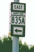
Only one (835A off Rt. 8 on Kent Island, shown at right) is posted with a suffix. Many of the
route numbers used for suffixes are themselves unposted, or there may not be a
non-suffixed 'main' route at all! The multi part, old alignment routes such as
7 and 144 have 'secret' suffixes for each individual section. The system is as
follows: Suffixed numbers
are used for very small connecting spurs to state highways.
Only one (835A off Rt. 8 on Kent Island, shown at right) is posted with a suffix. Many of the
route numbers used for suffixes are themselves unposted, or there may not be a
non-suffixed 'main' route at all! The multi part, old alignment routes such as
7 and 144 have 'secret' suffixes for each individual section. The system is as
follows:
MD 999: our imaginary route, the sections or spurs of which are designated...
999A through 999Z: lettered A-Z, usually increasing to the north or east.
The letters are used for internal purposes, and thus never appear on markers;
the letters 'I' and 'O' are used without legibility problems. Gaps in the
lettering occur often as some lettered routes are decommissioned.
In the rare case the single letters are depleted, then an additional letter
(based on county) is appended after the route number. The first letter corresponds
to the first letter in the county name, for example, in Baltimore County:
999BA through 999 BZ
And for Harford County:
999HA through 999 HZ
The journey of a thousand miles begins with a single step...
Or a thousand Maryland state routes, for that matter. I've arranged the routes in order in groups of twenty a
page, with the exception of the single digit numbers. Interstate and U.S. highways of a particular number are mentioned on that number's state page, but more information can be found on each Interstate U.S. highway's separate pages.
Hit the road!
Select from the links below.
|
|


