|
| Routes: State Routes: Interstates US Routes | Home |
| Routes 140-159 (120-139) Prev (160-179) Next |
Quick Links: Marked Unmarked
Decommissioned |
|
Frederick
Emmitsburg
Carroll
Taneytown
Westminster Finksburg Baltimore
Reisterstown
Owings Mills Garrison Pikesville Baltimore City
|
MD 140
· Reisterstown Rd, Westminster Pike, Baltimore Blvd, Taneytown Pike
49.72 mi.; from US 1 (North Ave.) in West Baltimore northwest to PA line
Marked north-south to south of Reisterstown, east-west to west of Reisterstown. Comprises former US 140 between Baltimore and Westminster. West of 97, 140 took over the former routing of MD 32. Associated Secret-Obscure Routes: NHS: |
140
49.7 PA 1649.7 PA Line 47.3 US 15 42.7 CR-FR Line 39.3 MD 194 37.9 MD 832 30.1 MD 832 29.1 MD 32 28.5 MD 31 28.1 MD 97* 27.1 MD 27 26.7 Center St 25.8 MD 97* 23.3 Reese Rd 21.8 Sandymount Rd 19.1 MD 91 19.0 MD 879 17.8 BA-CR Line 15.7 I-795 9 15.3 MD 30 13.4 Franklin Blvd 10.6 MD 940 9.1 MD 130 8.5 McDonough Rd 7.3 I-695 20 6.7 Old Court Rd 5.3 BC-BA Line 3.9 Northern Pkwy 2.4 Cold Spring La 1.2 MD 129* 1.0 MD 129* 0.7 MD 26 0.0 US 1 |
|
Carroll
Baltimore
Baltimore City |
US 140
· was Reisterstown Rd, Westminster Pike
current MD 140 from Baltimore northwest to Westminster, then MD 97 north to PA line.
Decommissioned 1979. Portion north of Westminster became MD 97, southeast of Westminster toward Baltimore became MD 140. |
|
|
Baltimore
Towson
|
MD 141
· was Allegany Ave.
0.89 mi.; from (now) Towson Circle west to Charles St Ave.
No longer assigned, decommissioned in 1960, transferred to Baltimore County maintenance. Four current or former state routes (five if you count US 111) radiate from the Towson Roundabout, of which Allegheny Ave. is the western approach. For the record, the routes are the current MD 45 and former US 111, York Rd. to the south and northwest; MD 146, Dulaney Valley Rd. to the north; Allegheny Ave., former MD 141 to the west; and East Joppa Rd., former MD 148, to the east. |
|
|
Baltimore
Wiseburg
White Hall Harford
Shawsville
|
MD 142
· was White Hall Rd.
2 pieces; from Wiseburg Rd to Kings Rd and from Vernon Rd to MD 23.
No longer assigned. Harford Co. portion decommissioned 1955, Baltimore Co. portions decommissioned 1979. |
|
|
Baltimore
Cockeysville
|
MD 143
· was Warren Rd.
2 pieces; from MD 45 (York Rd) east to Bosley Rd, and from eastern edge of Loch Raven Reservoir property to MD 146.
No longer assigned (decommissioned 1982). The break in state maintenance occurred where Warren Road entered Baltimore City property and maintenance. Dropped in 1982 when SHA picked up the gap in MD 145 to the north. (The water service and outlying reservoirs are maintained by the city.) MD 143 is still reflected in the choice of MD 943 as the new unsigned number for Warren Road's extension west to I-83 Exit 18. |
|
|
Allegany
Cumberland
Flintstone Pratt Washington
Hagerstown
Frederick
Frederick
New Market Carroll
Mt. Airy
Howard
Lisbon
Cooksville West Friendship Pine Orchard Ellicott City Baltimore
Catonsville
Baltimore City
|
MD 144
·
.
Marked east-west. Route 144 is the number given to all old sections of US 40 not otherwise marked Alt, Bus, or Scenic 40.
The number given to all former segments of US 40 west of Baltimore that for whatever
reason cannot be classified as Alternate, Business, or Scenic 40. Associated Secret-Obscure Routes: 771 999? The incarnations of MD 144 (east to west, away from Baltimore):
|
144
0.00 0 MD 1400.00 0 MD 140 0.00 0 MD 140 0.00 0 MD 140 0.00 0 MD 140 0.00 0 MD 140 0.00 0 MD 140 0.00 0 MD 140 0.00 0 MD 140 |
|
Baltimore
Towson
Timonium |
MD 144
· was Jarrettsville Pike
old number for MD 146 south of Loch Raven Reservoir
No longer assigned (decommissioned 194x). MD 146 in the area of Loch Raven Reservoir was once a 'break' in the route; in the 1930s, the southern part from the reservoir down to Towson was numbered 144. MD 146 then only consisted of the Jarrettsville Pike portion of the modern route. Most parts of what we now call 144 were still US 40 back then. |
|
|
Baltimore
Shawan
Jacksonville Baldwin |
MD 145
· Paper Mill Rd., Sweet Air Rd.
10.34 mi.; from MD 45 near Shawan east to MD 165.
Marked east-west. ................... |
145
0.0 MD 455.6 MD 146 10.3 MD 165 |
|
Harford
Madonna
Hess Baltimore
Jacksonville
Sunnybrook Towson |
MD 146
· Dulaney Valley Rd., Jarrettsville Pike
16.81 mi.; from MD 45 at Towson roundabout north to MD 23, Madonna.
Marked north-south. ................... |
146
16.8 MD 2315.1 MD 152 11.7 BA-HA Line 9.2 MD 145 5.0 Dulaney Valley Rd 3.3 Timonium Rd 1.6 Seminary Ave 0.8 I-695 27 0.3 Fairmount Ave 0.0 MD 45 |
|
Harford
Benson
Fallston Baltimore
Fork
Mount Vista Carney Parkville Baltimore City
|
MD 147
· Harford Rd.
18.81 mi.; from North Ave. (US 1) in East Baltimore northeast to US 1 / US 1 Business split south of Bel Air.
Marked north-south. ................... |
147
18.8 US 118.8 US 1 Bus 17.7 MD 152 15.9 BA-HA Line 7.1 Joppa Rd 6.5 I-695 31 6.1 Putty Hill Rd 5.3 Taylor Ave 5.2 BC-BA Line 4.4 Northern Pkwy 2.7 Moravia Rd 2.7 Cold Spring La 2.1 Walther Ave 1.0 Hillen Rd 0.9 MD 542 0.9 The Alameda 0.2 Broadway 0.0 US 1 |
|
Baltimore
Towson
Baynesville Perring Carney Perry Hall |
MD 148
· was Joppa Rd.
7.04 mi.; from MD 45 (now Towson roundabout, then US 111) east to US 1.
No longer assigned. Western terminus truncated to MD 542 in December 1959, remainder in July 1962. Now a shopping strip almost its entire length, the 148 designation still appeared on ADC atlases as late as 1983. I was surprised to find out how early this was dropped. Joppa offers an alternative for northeast side Beltway traffic to Towson. Westbound traffic takes a beating every morning rush hour, especially around several close traffic lights in the vicinity of Harford Rd. (MD 147) and Perring Parkway (MD 41). It's not half as bad in the afternoon rush, though. In any case, a road that was dropped as soon as it was anything other than rural, it now serves more traffic than ever as a numbered route. I would have kept at least the part east of MD 41 Perring Parkway, where I-695 begins to veer southward, making Joppa a tempting corner to Bel Air and points north on US 1. |
|
|
Baltimore
Whitemarsh
Chase |
MD 149
· was Ebenezer Rd [Chase]
2.17 mi. in 2 sections; from Bird River Rd. east to Earls Beach Rd, and from MD 150 west to Amtrak crossing.
Status: Decommissioned 1965 (SRC Min. 09-06-1960, effective 05-21-1965). Although Ebenezer Rd. is a through route between US 40 and MD 150, every old official
map shows MD 149 as not reaching US 40. It was in two pieces along Ebenezer, the first
roughly from just west of Bird River Rd. east to Earls Bach Rd., and the second a short
piece from the old Amtrak crossing to MD 150 in Chase. Baltimore County bypassed this old
crossing with a bridge in 1982. There is still a grade crossing to the north along the B&O tracks between US 40 and MD 7 (that section wasn't part of 149). This was the original Whitemarsh station, and the original town of Whitemarsh, sometimes called Cowenton, as opposed to White Marsh (zip 21162), the spelling used for the mall and as a catch-all for the suburban development between US 40 and US 1 that isn't otherwise Perry Hall (21128), Rosedale (21237) or Nottingham (21236). These zip codes are so tangled with each other, it borders on gerrymandering. I seem to be more into zip codes than roads here, but these are some issues people need to know if, say, they're having trouble finding a local address on Google Maps. Not only do we have tangled zips, but as you'll see next, we also have close duplicate road names. [Chase] is denoted above because there is another Ebenezer Rd to the west in Perry Hall. It extends east directly across US 1 from Joppa Rd (the part that was MD 148). It used to dead end, but now connects to very busy Honeygo Blvd. To confuse things further, to the north of [Perry Hall] Ebenezer Rd, there is a parallel Joppa Rd between US 1 and MD 7. From this Joppa Rd just east of Honeygo Blvd is Cowenton Rd, which connects directly across MD 7 to [Chase] Ebenezer Rd. The two Ebenezers may have connected in some manner in pre-automobile times. |
|
|
Baltimore
|
MD 149
· Windlass Freeway.
from I-95 at Moravia Rd. east to Middle River Rd.
Never built in its entirety. Section completed is now part of I-695. The Windlass Freeway was to run east from I-95 Exit 60 (Moravia Rd.) to an extended MD
43 north of Middle River. What was built was made part of MD 695 and later I-695. The rest
was officially killed in the mid seventies. SHA planning documents of the time referred to
the proposed Windlass as Maryland 149. |
|
|
Baltimore City
Baltimore
Eastpoint
Essex Middle River Chase |
MD 150
· Eastern Ave., Eastern Blvd., Eastern Ave. Ext.
13.07 mi.; from I-95 (?) east to end of SHA
maintenance at
Graces Quarters Rd., Chase.
Marked east-west.
Eastern Avenue does not carry MD 150 all the way to downtown
Baltimore, although it should run west to President St. Then again, the argument could be made that
150 doesn't enter Baltimore City at all. |
150
0.0 US 400.3 Baltimore St 0.4 Haven St 0.8 Lombard St 1.1 Ponca St 1.7 Dundalk Ave 2.3 I-95 59 2.5 BC-BA Line 3.2 - MD 151 4.1 I-695 38 5.5 Mace Ave 6.3 Marlyn Ave 7.0 MD 702 - 7.1 Stemmers Run Rd 8.4 - MD 700 9.0 MD 587 9.4 MD 43 10.5 Carroll Island Rd 11.1 Earls Rd 13.1 Grace's Quarters Rd |
|
Baltimore City
Baltimore
Eastpoint
Edgemere Sparrows Point |
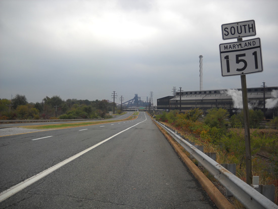
MD 151
· North Point Blvd., Erdman Ave.
10.80 mi.; from US 1 in Northeast Baltimore southeast to end of maintenance at 7th Street in Sparrows Point steel mill.
Marked north-south. North Point Blvd, like Eastern Blvd, was built to improve access to critical war manufacturing, in this case the Bethlehem Steel plant at Sparrows Point. The original 151 only consisted of Sparrows Point Rd from Old North Point Rd (former MD 20) in Edgemere southwest to the steel mill. MD 20 was, before the war, the only access to this area. The new North Point Blvd was given the 151 number and part of the old route used was, until 1999-2000, numbered MD 718. MD 151's function was partially supplanted in 1974 by the eastern section of I-695, which acts as something of a parallel bypass of 151. There was some uncertainty as to where the southern terminus of 151 was, besides generally being within the Severstal (formerly Mittal, formerly Bethlehem Steel) Sparrows Point Plant. Overhead signage announces that you're entering private property, but the road remains state maintained up to the first traffic signal at 7th Street. The numbered streets are a remnant of the old company town of Sparrows Point that the mill gradually swallowed up during its expansion in the middle of the 20th century. There was once a sign here stating that vehicle tags were required beyond that point. One can continue south to the end of Sparrows Point Blvd without encountering a gate (there is a county fire station across from the plant), and 151 may have continued all the way down, but there is no indication of this. The plant itself, like all U.S. manufacturing, has been on a long-term downward slide. The plant that once employed enough workers to necessitate two county toll bridges over Bear Creek, at Dundalk Ave (demolished), and Peninsula Expressway (upgraded to MD 157 in 1999) now employs less than 2000. Everything has essentially shut down with the exception of the tin mill. Sections of MD 151:
|
151
10.8 US 110.6 Edison Hwy 10.1 Sinclair La 8.9 US 40 7.6 BA-BC Line 7.3 Baltimore St 6.9 MD 150 6.1 MD 157 6.1 Merritt Blvd 5.3 I-695 40 4.2 Cove Rd 2.7 Wise Ave 1.9 I-695 42 1.7 MD 158 0.9 Sparrows Pt Rd 0.5 Wharf Rd 0.0 BSM |
|
Harford
Upper Crossroads Scarff Fallston Pleasant Hills Mountain Joppa Joppatowne |
MD 152
· Magnolia Rd, Mountain Rd, Fallston Rd
17.34 mi.; from MD 146 southeast to gates of Edgewood Area of Aberdeen Proving Ground.
Marked north-south. Marking the beginning of Harford County's allocation of numbers (152-165), 152 parallels the southwestern edge of the county. It has become more congested in recent years between I-95 and US 1 with increased development. In some parts it has been widened from 2 to 3 lanes. |
152
17.3 MD 14613.7 MD 165 8.0 MD 147 7.6 US 1 3.3 I-95 74 3.0 MD 7 2.4 US 40 0.0 End |
|
Frederick
Wolfsville
Ellerton Myersville |
MD 153
· was Wolfsville Rd
now MD 17 north of US 40.
No longer assigned, entire route now part of MD 17. Created when MD 17 between US 40 and Alt US 40 was dropped from state maintenance. The northern remnant of 17 was designated MD 153. Later, around 1986, the lost stretch was reclaimed, and 17 returned to its original length. |
|
|
Harford
Bel Air
Emmorton Edgewood |
MD 153
· was Emmorton Rd
Old number for MD 24 south of Bel Air to MD 7.
No longer assigned (decommissioned 193x), entire route now MD 924. Disappeared quickly; only reference to this 153 being in a 30s operating budget. |
|
|
Harford
Churchville
|
MD 154
· was Thomas Run Rd.
north off MD 22 at Harford Community College.
No longer assigned (decommissioned 195x). ................... |
|
|
Harford
Churchville
Level Webster Havre de Grace |
MD 155
· Level Rd, Superior St, Ohio St
9.12 mi.; from MD 22 in Churchville east to US 40 in Havre de Grace.
Marked east-west. Associated Secret-Obscure Routes: ................... |
155
0.0 MD 223.8 MD 161 4.5 MD 156 4.8 MD 462 6.6 I-95 89 8.8 MD 763 9.1 MD 7a 9.1 US 40 |
|
Harford
Churchville
|
MD 156
· Aldino Rd
3.92 mi.; from MD 22 east of Churchville east to MD 155 near Webster.
Marked east-west. Routes 155 and 156 may have swapped places in the 40s or 50s. |
156
0.0 MD 223.9 MD 155 |
|
Baltimore
Eastpoint
Dundalk Sparrows Point |
MD 157
· Peninsula Expwy., Merritt Blvd.
4.79 mi.; from I-695 Exit 43 north to I-695 Exit 39.
Marked north-south. An expressway in name only, this road picked up by SHA along with 158 in the early nineties. Originally ending at the southern end of the Peninsula Bridge over Bear Creek, SHA in 1999 has picked up maintenance of the rest of Peninsula Expwy. and also Merritt Blvd north of same, forming an L shaped route going all the way north to I-695 Exit 39. Peninsula Expwy. was built over Bear Creek as one of two bridges, the extinct Dundalk Ave. being the other. Both these bridges once carried a 15 cent toll. On the north side of the bridge you can see the old toll booth building. |
157
5.1 I-695 394.9 MD 151 4.8 Old North Pt Rd 4.3 German Hill Rd 3.5 Holabird Ave 3.5 Wise Ave 2.7 Merritt Blvd 1.4 Bear Creek Br 0.1 I-695 43 0.0 MD 158 |
|
Harford
Webster
Havre de Grace |
MD 157
· was Chapel Rd.
00.00 mi.; from ... to ...
No longer assigned (decommissioned 198x). ................... |
|
|
Baltimore
Sparrows Point
Edgemere |
MD 158
· Bethlehem Blvd.
2.35 mi.; from Beth Steel Ship Entrance east to MD 151 near Edgemere.
Marked east-west. Parallels I-695 Key Bridge approach, which is being changed from 2 lane overpass to 4 lanes at ground level, and 158 has to be reconfigured to accommodate. |
158
0.0 Tin Mill Rd1.1 MD 157 1.5 Wharf Rd 2.2 MD 151 2.4 North Pt Rd |
|
Harford
Belcamp
|
MD 158
· was Belcamp Rd.
00.00 mi.; from ... to ...
No longer assigned (decommissioned 198x), most of road no longer exists. Most of this road no longer exists, having been removed for a subdivision. Southern terminus was at US 40 near the Bata shoe factory west of Aberdeen. |
|
|
Harford
Bush River
Perryman Aberdeen |
MD 159
· Perryman Rd, Old Philadelphia Rd
4.73 mi.; from dead end at Bush River east to US 40.
Marked east-west. MD 159 took over the part of MD 7 between it and US 40 when the latter was dropped from state maintenance from Old Philadelphia Rd east of 159 to Aberdeen. |
159
0.0 Begin1.9 Canning House Rd 3.2 Spesutia Rd 4.4 Old Philadelphia Rd 4.7 US 40 |


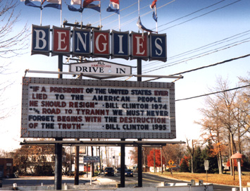 Bengies Drive-In
along MD 150, looking west, one of the last drive-ins in the East. The message pertains to the Clinton-Lewinsky scandal. (photo 10-31-98)
Bengies Drive-In
along MD 150, looking west, one of the last drive-ins in the East. The message pertains to the Clinton-Lewinsky scandal. (photo 10-31-98)