|
| Routes: State Routes: Interstates US Routes | Home |
| Routes 160-179 (140-159) Prev (180-199) Next |
Quick Links: Marked Unmarked
Decommissioned |
|
Harford
Darlington
|
MD 160
· was Shuresville Rd.
from MD 161 northeast to US 1.
No longer assigned (decommissioned). ................... |
|
|
Harford
Darlington
Level |
MD 161
· Darlington Rd.
5.38 mi.; from MD 155 near Level north to US 1 near Darlington.
Marked north-south. ................... |
161
5.4 US 15.2 MD 623 0.0 MD 155 |
|
Anne Arundel
BWI Airport
|
MD 162
· Aviation Blvd.
2.31 mi.; from MD 170 south to MD 176.
Marked north-south. Forms eastern perimeter of BWI Airport. Was once Hammonds Ferry Road and numbered route 167. Associated Secret-Obscure Routes: 762 |
162
2.3 MD 1701.8 MD 762 0.4 Hollins Ferry Rd 0.3 I-97 (sb) 15 0.0 MD 176 |
|
Harford
Castleton
|
MD 162
· was Smith Rd
northeast off US 1 to road end
No longer assigned (decommissioned). Connects US 1 to approximate location of old Susquehanna crossing before the Conowingo Dam was built. Later 162 was dropped; MD 623 now traverses the general area. |
|
|
Harford
Federal Hill
|
MD 163
· was Fawn Grove Rd
from MD 165 north ~1 mile
No longer assigned (decommissioned). Former route appears to end before Jerrys Rd. |
|
|
Cecil
Charlestown
|
MD 164
· was Carpenters Point Rd.
from MD 267 south to dead end.
No longer assigned (decommissioned). May have existed as late as 1972. |
|
|
Harford
Cardiff
Whiteford Pylesville Federal Hill Jarrettsville Putnam Upper Crossroads Baltimore
Baldwin
|
MD 165
· Baldwin Mill Rd, Federal Hill Rd
20.38 mi.; from old Ma & Pa rail crossing north to PA Line near Delta.
Marked north-south. Associated Secret-Obscure Routes: 757 The Ma & Pa (Maryland & Pennsylvania Railroad) stopped service around 1955. The only sign the tracks were there is a slight grade and a 'Begin State Maintenance' sign on 165. |
165
20.4 PA 85120.4 PA Line 19.6 MD 136 17.2 MD 543 16.3 MD 624 15.1 MD 24 8.2 MD 23* 6.9 MD 23* 3.6 MD 152 1.4 BA-HA Line 0.8 MD 145 0.0 Begin |
|
Baltimore
Catonsville
Arbutus |
MD 166
· S. Rolling Rd.
2.71 mi.; from MD 144 south to I-195.
Marked north-south. So named because this road was used in colonial times to roll casks of tobacco downhill from Catonsville to waiting ships on the Patapsco River near Elkridge. This route doesn't technically fit into a numbering cluster, being in southwestern Baltimore County, but close to the part of Anne Arundel County where the next cluster begins. Associated Secret-Obscure Routes: 466 |
166
2.7 MD 1441.7 Bloomsbury Ave 1.5 Valley Rd 1.0 MD 372 0.0 I-195 |
|
Anne Arundel
Linthicum
|
MD 167
· was Hammonds Ferry Rd.
from Anne Arundel-Baltimore County line south to MD 176.
No longer assigned (decommissioned), part of route now MD 162, MD 762. Only reminder of this route is the fact that both 168 and 169 end here. The group of routes 167-179 puts us in northern and central Anne Arundel County. The southern half of this route between MD 170 and MD 176, is now signed as MD 162 and named Aviation Blvd; it forms the eastern perimeter of BWI Airport. The entire route was dropped in 1960; the part of 167 along the airport perimeter was revived in the early 70s, and later changed to 162. |
|
|
Anne Arundel
Linthicum
|
MD 168
· Nursery Rd.
1.28 mi.; from Hammonds Ferry Rd. near I-695 Exit 8 east to Md 648.
Marked east-west. Plenty of fast food and gas near I-695 Exit 8, otherwise not much to speak about. Associated Secret-Obscure Routes: 969 |
168
0.0 Hammonds Ferry Rd0.2 I-695 8 0.3 MD 969 1.3 MD 648 |
|
Anne Arundel
Linthicum
|
MD 169
· Maple Rd.
0.97 mi.; from Hammonds Ferry Rd. east to MD 648.
Marked east-west. Otherwise an unassuming residential street. I would figure SHA would drop this route should they get around to it. |
169
0.0 Hammonds Ferry Rd0.3 MD 170 0.7 MD 648 |
|
Anne Arundel
Brooklyn Park
Pumphrey Linthicum BWI Airport Harmans Severn Odenton |
MD 170
· Belle Grove Rd., Telegraph Rd., Camp Meade Rd.
12.98 mi.; from MD 2 near Baltimore city line south to MD 175, Odenton
Marked north-south. South end was at Odenton Rd (former MD 677) before being rolled back to MD 175 in 2004. Associated Secret-Obscure Routes: 652 |
170
13.0 AA-BA Line13.0 MD 2 10.7 MD 648 10.3 I-695 6 9.9 MD 169 9.1 MD 762 8.7 MD 162 7.5 I-195 1 7.1 MD 995 5.2 MD 176 4.4 MD 100 11 3.5 MD 174 1.0 MD 32 0.0 MD 175 |
|
Baltimore City
|
I-170
·
between Franklin/Mulberry Sts. (US 40)
No longer assigned (decommissioned 1989), now signed as US 40. ................... |
|
|
Anne Arundel
Glen Burnie
Baltimore City
|
MD 171
· Church St.
1.54 mi.; from MD 2 east to (Baltimore city line or) MD 173.
Marked east-west in Anne Arundel County, unmarked in Baltimore City. Should run to Patapsco Ave. (MD 173) in Baltimore City, but again neither 171 nor 173 are signed in the city. |
171
0.0 MD 20.9 AA-BA Line 1.5 MD 173 |
|
Baltimore City
Anne Arundel
Curtis Bay
|
MD 172
· Arundel Cove Ave.
from MD 173 south to Coast Guard station entrance.
Unmarked. Once called Colfax Ave. Coast Guard facility is in Anne Arundel County while only road access was across the Baltimore City line to 173. I don't know if it was ever signed. |
|
|
Baltimore City
Anne Arundel
Foremans Corner
Riviera Beach |
MD 173
· Fort Smallwood Rd.
13.73 mi.; from MD 2 southeast to Ft Smallwood Park.
Marked east-west. Also included Hawkins Pt. Rd. and Patapsco Ave. east of MD 2 in the city, but city signage was neglected long ago. Mileage begins at the southeastern end (Ft. Smallwood). Associated Secret-Obscure Routes: 642 |
173
13.7 MD 212.4 Patapsco Ave 11.7 MD 171 10.7 MD 710 10.3 Drawbridge 9.7 MD 172 9.2 Quarantine Rd 8.8 AA-BC Line 8.1 Marley Neck Rd 7.6 Solley Rd 5.9 MD 642 5.1 Riviera Dr 5.1 Bar Harbor Rd 4.1 Duvall Hwy 3.9 Edwin Raynor Blvd 3.0 MD 607 0.0 Ft Smallwood |
|
Anne Arundel
Ft. Meade
Severn Glen Burnie |
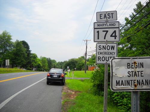
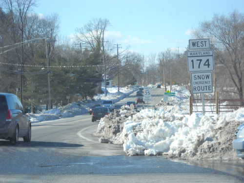
MD 174
· Reece Rd., Donaldson Ave., Quarterfield Rd.
5.94 mi.; from end of state maintenance at Jacobs Road northeast to Business MD 3.
Marked east-west. Began as a mere sliver west of Business 3. Donaldson Avenue was realigned at MD 170 in 1983, taking over old MD 554 (Reece Rd.) west of MD 170 all the way to the end of state maintenance at the property line of Fort Meade near Jacobs Road. MD 174 does not extend all the way down Reece Road to MD 175 and Fort Meade. There is a "Begin State Maintenance" sign at Jacobs Road, and the turnoff for Reece Road off of 175 says "TO MD 174." A tip of the MDRoads cap to Gary Metzler for this 174 info:
Associated Secret-Obscure Routes: 483 554 779 |
174
0.0 BSM2.5 MD 170 4.9 I-97 13 5.2 MD 779 5.6 MD 100 14 5.9 MD 3 Bus |
|
Howard
Columbia
Waterloo Jessup Anne Arundel
Ft. Meade
Odenton Gambrills Millersville |
MD 175
· Rouse Parkway, Waterloo Rd, Jessup Rd, Annapolis Rd
17.01 mi.; from US 29 in Columbia southeast to MD 3 in Millersville.
Marked east-west. Now an 4-6 lane main drag in Howard County, MD 175 once began at MD 103, running along the current 104 and 108. North of 104 to US 29, it now takes the route of old MD 539. On its southern end, it once ran past 3 to 178 near I-97 Exit 5. In the years around World War II, 175 ran northeast from Fort Meade along what is now MD 713; current 175 south of Ft. Meade was MD 180. Though MD 175 runs diagonally NW-SE, signage is east-west, to be perpendicular to the NE-SW diagonal corridors it intersects (US 29, I-95, US 1, MD 295, MD 3) that are all signed north-south. Associated Secret-Obscure Routes: 180 539 677 723 |
175
17.0 ESM16.6 US 29 20 14.9 Tamar Dr 14.0 Dobbin Rd 13.4 Snowden River Pkwy 12.5 MD 108 12.0 I-95 41 11.4 US 1 9.8 AA-HO Line 9.7 MD 723 9.0 Brock Bridge Rd 8.4 MD 295 7.3 MD 713 5.9 Reece Rd 4.3 MD 32 3.3 MD 170 2.3 MD 677 0.1 MD 3 (sb) 0.0 MD 3 (nb) |
|
Anne Arundel
Harmans
BWI Airport Glen Burnie |
MD 176
· Dorsey Rd.
5.68 mi.; from cul-de-sac near MD 100 southeast to MD 648.
Marked east-west. MD 176 be truncated at the west end due to construction of new MD 100 in the late 1990s. It used to extend west into Howard County to US 1. During construction of MD 100, 176 was realigned to line up with MD 103 on the other side. After the opening of MD 100, MD 176 was rolled back to near Ridge Rd/Arundel Mills Blvd (MD 713) and MD 100 took over 176's interchange with the B/W Parkway (MD 295). MD 103 took over the old alignment of MD 176 (Dorsey Road) west of the B/W Parkway in October 1996. Associated Secret-Obscure Routes: 645 |
176
0.0 BSM0.9 MD 713 2.1 MD 176 2.7 MD 652 4.7 MD 162 5.0 I-97 15 5.7 MD 648 |
|
Anne Arundel
Harundale
Armiger Jacobsville Lake Shore Gibson Island |
MD 177
· Mountain Rd.
10.92 mi.; from MD 2 east to gated entrance to Gibson Island.
Marked east-west. Begins at MD 2 near Marley Station mall and MD 100, ending at the private gated community of Gibson Island on the Magothy River. Unusually for a surface route, MD 177 has a third, signalized reversible center lane from MD 100 east to South Carolina Ave. Normally this is a center turn lane, but can be made one way to accomodate peak traffic. The eastern end at the Gibson Island gate is marked with "END 177" signage. |
177
0.0 MD 20.6 MD 10 0.8 MD 648* 2.0 MD 648* 2.0 Solley Rd 2.9 Catherine Ave 3.7 Edwin Raynor Blvd 4.2 MD 607 5.2 MD 100 5.3 MD 990 10.9 Gibson Isl Gate |
|
Anne Arundel
Dorrs Cor.
Crownsville Parole |
MD 178
· Generals Hwy.
8.06 mi.; from MD 450 north to Old Crain Hwy. (former MD 3)
Marked north-south. General George Washington traveled this road to Annapolis to formally resign his commission after the Revolution, thus the name. Associated Secret-Obscure Routes: 798 |
178
8.1 Veterans Hwy5.4 I-97 5 5.1 Herald Harbor Rd 4.2 Crownsville Rd 2.5 MD 798 0.3 Bestgate Rd 0.0 MD 450 |
|
Anne Arundel
Cape St Claire
|
MD 179
· St. Margarets Rd.
3.16 mi.; from MD 648 northeast to US 50-301 Exit 29.
Marked east-west. Once extended east to Skidmore, near Sandy Point, but its former route lies beneath current US 50-301 and its frontages. Associated Secret-Obscure Routes: 931 |
179
0.0 MD 6482.4 MD 908 2.6 US 50-301 29 2.8 College Pkwy 3.2 ESM |