|
| Routes: Interstates US Routes State Routes: | Home |
| Routes 600-619 (580-599) Prev (620-639) Next |
Quick Links: Marked Unmarked
Decommissioned |
|
Baltimore |
MD 600
· was Old Eastern Avenue
3 sections
No longer assigned (decommissioned 1956, 1970), transferred to Baltimore County maintenance. Associated with MD 600. Continuing our cluster in Middle River, MD 600 consists of sections of MD 150 bypassed when Eastern Blvd was constructed during World War II. Was still officially Eastern Avenue on signage into the middle 1980s, but everyone called it 'Old Eastern' as long as I can remember. According to SRC data, the mainline section of Old Eastern, the one that was actually usable as a connector, was dropped in 1956, and the other stubs were kept until 1975. Sections of MD 600: All of these in the same general area of Middle River, except 600C which is just west of the Back River Bridge near Essex. |
|
|
Baltimore Middle River
|
MD 601
· was Harrison Avenue
0.16 mi.; from Eastern Blvd (MD 150) north to Baker Ave (former MD 599).
No longer assigned (decommissioned 1975). MD 601 provided straight-on access to MD 150 from the other streets in old Middle River. At the southern end we have Faith Lutheran Church, and at the northern is the old Middle River post office, from the days when proximity to the railroads mattered.
|
|
|
Anne Arundel Maryland City
|
MD 602
· was Fort Meade Rd.
No longer assigned, route now part of MD 198. ...................
|
|
|
|
MD 603
Not assigned. |
|
|
Montgomery Damascus
|
MD 604
· was Watkins Rd.
0.66 mi.; from southeast of Cedar Grove toward Woodfield
No longer assigned (decommissioned 1958), transferred to Montgomery County maintenance. |
|
|
Montgomery Takoma Park
|
MD 605
· was Takoma Avenue
from Washington DC Line to Fenton Street
No longer assigned (decommissioned 1999), transferred to Takoma Park municipal maintenance. Was not signed even when it was in the state system. Dropped in 1999 with the big cleanup of Montgonery County state routes. |
|
|
Queen Anne's Centreville
|
MD 606
· was Corsica Neck Road
from Spider Web Rd east to western limits of Centreville.
No longer assigned, now part of MD 304. Annexed by MD 304 in 1951. |
|
|
Anne Arundel Jacobsville
|
MD 607
· Hog Neck Rd.
1.54 mi.; from MD 173 south to end of state maintanance at Seaborne Rd.
Marked north-south. ................... |
607 |
|
Carroll Sykesville
|
MD 608
· was Arrington Rd.-Raincliffe Rd.
00.00 mi.; from ... to ...
No longer assigned (decommissioned 1950s). ................... |
|
|
Montgomery Norbeck
|
MD 609
· was Norbeck Rd.
00.00 mi.; from ... to ...
No longer assigned (decommissioned), now part of MD 28. ................... |
|
|
Worcester Whaleyville
|
MD 610
· Whaleyville Rd.
6.53 mi.; from MD 353 northeast to US 113.
Marked, no cardinal directions. This route does not reach south to US 50. As of 1999 it only says "TO 610" at 50's intersection with Whaleyville Rd. |
610
0.0 US 1130.0 MD 000 0.0 MD 000 0.0 MD 353 |
|
Worcester West Ocean City
Sinepuxent |
MD 611
· Stephen Decatur Hwy.
8.51 mi.; from US 50 south to Assteague State Park.
Marked north-south. ................... |
611
0.0 US 500.0 MD 626 0.0 BSM |
|
Carroll Harney
|
MD 612
· was Harney Rd.
from PA line south to near Conover Rd.
No longer assigned (decommissioned 1956). A short route near Harney in extreme northwest Carroll County, this road becomes PA 134 at the state line. It didn't touch any other routes. |
|
|
Anne Arundel North Beach
|
MD 613
· was Friendship Rd.
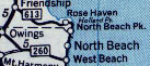
old number for MD 261 from MD 2 east to Boyds Turn Rd.
No longer assigned (decommissioned), now part of Route 261. From a 1948 map, before 261 was brought north of North Beach into Anne Arundel County.
|
|
|
Montgomery Bethesda
|
MD 614
· Goldsboro Rd
1.97 mi.; from MD 396 east to MD 191.
Marked east-west. ................... ................... |
614
0.00 0 MD 6000.00 0 MD 600 0.00 0 MD 600 0.00 0 MD 600 0.00 0 MD 600 |
|
Washington Hancock
|
MD 615
· Heavenly Acres Ridge Rd
4.35 mi.; from I-70 Exit 5 north to PA line.
Marked north-south. ................... |
615
0.00 0 MD 6000.00 0 MD 600 0.00 0 MD 600 0.00 0 MD 600 0.00 0 MD 600 0.00 0 MD 600 0.00 0 MD 600 0.00 0 MD 600 0.00 0 MD 600 |
|
County
Town 1
Town 2 Town 3 County
Town 1
Town 2 Town 3 |
MD 616
· Road Name Here
00.00 mi.; from ... to ...
Marked Unmarked No longer assigned (decommissioned). north-south. east-west. ................... ................... |
616
0.00 0 MD 6000.00 0 MD 600 0.00 0 MD 600 0.00 0 MD 600 0.00 0 MD 600 0.00 0 MD 600 0.00 0 MD 600 0.00 0 MD 600 0.00 0 MD 600 |
|
County
Town 1
Town 2 Town 3 County
Town 1
Town 2 Town 3 |
MD 617
· Road Name Here
00.00 mi.; from ... to ...
Marked Unmarked No longer assigned (decommissioned). north-south. east-west. ................... ................... |
617
0.00 0 MD 6000.00 0 MD 600 0.00 0 MD 600 0.00 0 MD 600 0.00 0 MD 600 0.00 0 MD 600 0.00 0 MD 600 0.00 0 MD 600 0.00 0 MD 600 |
|
County
Town 1
Town 2 Town 3 County
Town 1
Town 2 Town 3 |
MD 618
· Road Name Here
00.00 mi.; from ... to ...
Marked Unmarked No longer assigned (decommissioned). north-south. east-west. ................... ................... Sections of MD 600: |
618
0.00 0 MD 6000.00 0 MD 600 0.00 0 MD 600 0.00 0 MD 600 0.00 0 MD 600 0.00 0 MD 600 0.00 0 MD 600 0.00 0 MD 600 0.00 0 MD 600 |
|
Caroline Denton
|
MD 619
· Sixth St
1.09 mi.; from MD 313-404 Denton Bypass interchange south to Bus MD 404 in Denton.
Unmarked, associated with old sections of MD 313. ................... ................... |
|


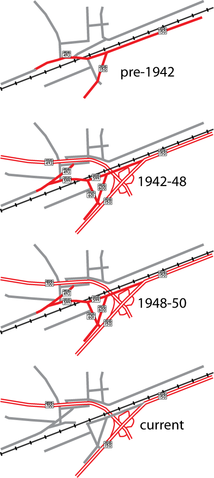 Middle River area routes, showing the 599-600-601 cluster.