
|
| Routes: Interstates US Routes State Routes: | Home |
| Routes 580-599 (560-579) Prev (600-619) Next |
Quick Links: Marked Unmarked
Decommissioned |
7
|
Somerset
W. Pocomoke City
|
MD 580
· was Pocomoke River Rd
loop east off MD 364 just north of US 13.
No longer assigned (decommissioned). Just across the river from Pocomoke City, MD 580 is only mentioned in the 1937 SRC operating budget. |
|
|
Carroll
Tyrone
|
MD 581
· was Keysville-Frederick County Rd., Keysville-Bruceville Rd.
approximately 2 miles either side of Keysville.
No longer assigned (decommissioned 1956). . |
|
|
Montgomery
Laytonsville
Mt. Zion |
MD 582
· was Mt. Zion Rd.
from Brink Rd. (old MD 420) south to MD 108.
No longer assigned (decommissioned). May have lasted into the 1970s. |
|
|
Howard
Florence
Glenwood |
MD 583
· was Jennings Chapel Rd.
from MD 94 east to MD 97.
No longer assigned (decommissioned). |
|
|
St. Mary's
St. Mary's City
|
MD 584
· (unnamed)
loop west of MD 5.
Unmarked. A short loop into St. Mary's City, Maryland's first capital. |
|
|
Wicomico
Salisbury
|
MD 585
· was Airport Rd.
from MD 12 to MD 350
No longer assigned (decommissioned). |
|
|
Montgomery
Rockville
Kensington Wheaton |
MD 586
· Viers Mill Rd.
5.78 mi.; from MD 28/MD 911, Rockville east to MD 97, Wheaton
Marked east-west. ................... |
586
0.0 MD 280.0 MD 911 4.0 MD 185 5.4 MD 193 5.8 MD 97 |
|
Baltimore |
MD 587
· Wilson Point Rd.
1.14 mi.; from MD 150 south to Dogwood Dr.
Marked north-south.
Once ran the entire 2.2 miles to a dead end at the tip of Wilson Point; its southern end was rolled back to Dogwood Dr in 1986. It's unusual in that being a dead end, it's mostly divided. It also serves as the main entrance to Martin State Airport. It is also, for your intrepid reporter, the road home. |
587 |
|
Baltimore
Overlea
Kenwood Rosedale |
MD 588
· Golden Ring Rd., Kenwood Ave.
1.94 mi.; from MD 7 north to end of state
maintenance at Brookwood Dr.
Marked north-south. Don't know why this one is still around, but it's been this way since at least 1935. I recall a time in the mid 1980s when 588 may not have been signposted. Passes over I-95 with no access. The route should be dropped or switched over to the parallel (just the other side of I-695) six-lane Rossville Blvd. instead of its current two-lane routing. |
588
1.9 ESM1.8 Lillian Holt 0.6 Golden Ring Rd 0.6 Kenwood Ave 0.0 MD 7 |
|
Worcester
Ocean Pines
|
MD 589
· Race Track Rd.
4.65 mi.; from US 50 north to US 113.
Marked north-south. The namesake race track is Ocean Downs. Not the only Race Track Road to have been a state route; another in Bowie was once MD 703. |
589
4.7 US 1134.6 MD 575 2.6 - MD 90 0.1 MD 707 0.0 US 50 |
|
Harford
Kalmia
|
MD 590
· was Forge Hill Rd.
loop east off US 1.
No longer assigned (decommissioned). This winding road was part of US 1 before it was replaced by a new bridge and straighter approach in 1934. The old bridge appears abandoned, but it is open, and seems to be a popular parking spot. |
|
|
Cecil
Richardsmere
|
MD 591
· Colora Rd, Porters Bridge Rd
2 pieces; loop south off US 1.
Marked north-south on east section, east-west on west section. Another piece of an old US 1 bridge, bypassed in 1933. This bridge over Octoraro Creek was closed, but still visible from either end in 1999. By 2003 the bridge had been dismantled. Steel grating had been welded over both entrances to prevent people from walking on the rotting wood planks that make up its surface. Colora Rd is the western section (591A) and Porters Bridge Rd is the eastern (591B). |
|
|
Cecil
Rising Sun
|
MD 592
· was Half Mile Loop
from MD 273 northeast to Sylmar Road.
No longer assigned (decommissioned). An early bypass of Rising Sun for US 1, itself bypassed further north and west. |
|
|
Montgomery
Kensington
|
MD 593
· was Brunett Ave.
0.86 mi.; from Sligo Creek Parkway North through Argyle Park to End SRC Maintenance.
Decommissioned 1958, number no longer assigned. (SHA Min. 08-14-1958, effective same) Email from Mark Stein:
|
|
|
Montgomery
Silver Spring
|
MD 594
4 sections
MD 594 makes a comeback due to construction of the Purple Line subway between Silver Spring and New Carrollton. Sections A-D involve roads on or near the new rail line in Montgomery County, while E-F were in Prince George's County. SHA District 3 (which includes PG County) requested a renumbering for their sections to MD 431 and MD 433. Sections of MD 594: All of these are along the route of the Purple Line subway |
|
|
Montgomery
Silver Spring
|
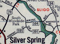
MD 594
· was Wayne Avenue
0.41 mi.; from Dartmouth Avenue across MD 391 to MD National Capital Park
Decommissioned 1958, number no longer assigned. (SHA Min. 08-14-1958, effective same)
|
|
|
Prince George's
Anne Arundel
|
I-595
· John Hanson Highway
19.97 mi.; from I-495 east to MD 70.
Unmarked as an Interstate, signed as US 50 or 50-301. I-595 has its own page in the Interstate section. Also check out the pages for US 50 and US 301. |
|
|
Montgomery
Silver Spring
|
MD 595
· was Bonifant St.
0.12 mi.; from former MD 391 (Dale Drive) to Queen Anne Drive (CO 633).
Decommissioned 1958, number no longer assigned. (SHA Min. 08-14-1958, effective same) Dropped at the same time as 593 and 594. Two blocks of Bonifant are now (at least temporaily) MD 594B and 594C. |
|
|
Montgomery
Silver Spring
|
MD 596
· was Maple Ave
0.09 mi.; from MD 391 (Dale Drive) to Woodside Parkway (CO 608).
Decommissioned 1958, number no longer assigned. (SHA Min. 08-14-1958, effective same) |
|
|
Howard
Elkridge
|
MD 597
· was Bonnie View Rd.
loop south off US 1 cut off on west side, NW of Harwood Park
No longer assigned (decommissioned). ................... |
|
|
Montgomery
Forest Grove
|
MD 597
· was Forest Glen Rd.
old number for current MD 192 between MD 97 and US 29
No longer assigned (decommissioned), entire route now part of MD 192. ................... |
|
|
Somerset
Princess Anne
|
MD 598
· was Old Princess Anne Rd
loop east of current US 13
No longer assigned (decommissioned). ...................
|
|
|
Baltimore
Middle River
|
MD 599
· was Old Orems Rd., Baker Ave.
3 sections
No longer assigned (decommissioned 1975), transferred to Baltimore County maintenance. MD 599 was the remnant of a railroad crossing elimination for MD 493, later to be overlaid by MD 700 (Martin Blvd). Routes 600 and 601 are also in this same area, so be sure to check the next page for those. Sections of MD 599: All of these in the same general area of Middle River |
|


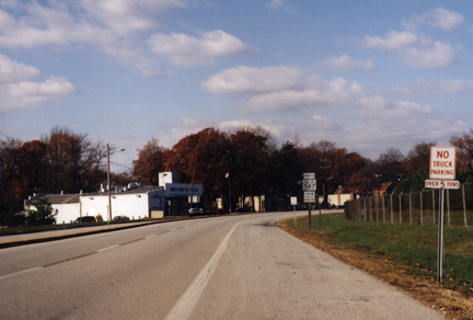 MD 587, Wilson Point Road, nortbound, at Dogwood Drive. (photo 10/31/98)


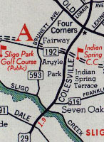 Brunett Ave. as MD 593, from a 1956 General Drafting map.


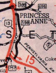 MD 598, from the 1948 SRC map.
