|
| Routes: Interstates US Routes State Routes: | Home |
| Routes 780-799 (760-779) Prev (800-819) Next |
Quick Links: Marked Unmarked
Decommissioned |
|
|
MD 780
not assigned
|
|
|
Cecil
Elkton
|
MD 781
· Delancy Rd
1.01 mi.; from US 40 north to MD 281 east of Elkton.
Status: Signed north-south. Added to state maintenance in 1984 (SHA Min. 06-11-1984, Agreement Effective 05-16-1984). Number comes from MD 281 at its north end. For both 281 and US 40, it's the last junction before entering Delaware. |
781
1.0 MD 2810.0 US 40 |
|
|
MD 782
not assigned
|
|
|
Anne Arundel
Weems Creek
|
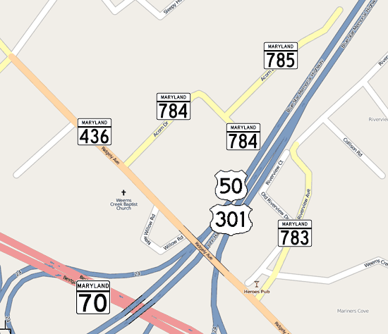
MD 783
· Riverview Ave
0.23 mi.; from MD 436 east to road end.
Status: Unsigned. A short spur east off MD 436 just south of US 50-301, meant to reconnect areas cut off by the limited access upgrade from MD 70 to the Bay Bridge with a new connector further away from MD 436 bridge over US 50. This is a dead end, but still in state maintenance.
|
|
|
Anne Arundel
Weems Creek
|
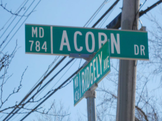
MD 784
· Acorn Dr, Pafel Rd
0.24 mi.; from MD 436 east to road end.
Status: Unsigned by the state, although it does appear on Anne Arundel street name blade signage. Does the same thing as 783, but connects streets on the north side of US 50/301.
|
|
|
Anne Arundel
Weems Creek
|
MD 785
· Acorn Dr
0.29 mi.; from MD 784 east to road end.
Status: Unsigned. An additional length of Acorn Dr east of the part that is 784, which goes straight onto Pafel Rd. |
|
|
Anne Arundel
Winchester
|
MD 786
3 sections
Status: MD 786A Decommissioned 1983, transferred to Anne Arundel County maintenance. (SHA Min. 01-28-1983, Agreement 11-15-1982); MD 786B Decommissioned 1988, transferred to Anne Arundel County maintenance. (SHA Min. 06-22-1986, Agreement 05-20-1986). Winchester was a little-known stop along the old Baltimore & Annapolis Railroad. MD 786A ran parallel along the south edge of US 50-301 to the east of the Severn River Bridge. Sections of MD 786: |
|
|
Montgomery
Takoma Park
|
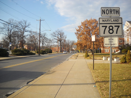
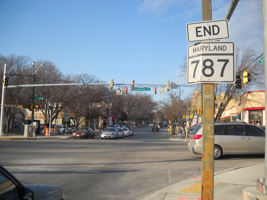
MD 787
· Flower Ave
0.99 mi.; from MD 195 (Carroll Ave) north to MD 320 (Piney Branch Rd).
Status: Signed north-south, decommissioning/transfer to Takoma Park municipal maintenance is pending. MD 787 began life as MD 194, before that number was needed for the current 194 in Frederick/Carroll County (that had itself been the first MD 71). It managed to stick around through the decommissionings of the 1950s that took down nearby routes like 540 and 593-596 inclusive. In the 1999 decommissioning in Montgomery County, MD 787 had its northern half (0.88 miles) above MD 320 shorn off, prior to which it had extended to Franklin Ave, which had been MD 516, dropped at the same time. Also disappearing in the area were 184, 339, 391 and the unsigned 605 (a piece of Takoma Avenue). Washington Adventist Hospital and University are at the southern end in Takoma Park. Traveling north, Flower Avenue straddles the Takoma Park corporate limits. As of early 2011, a bill is pending for Takoma Park to formally annex the entire road, taking over maintenance from SHA. This part (MD 787) has been decoupled from the MD 410 controversy, where that route's ownership may never be proven by either side. Takoma Park is also planning a Portland-style 'green street', with pedestrian accommodation and traffic calming. The west side currently has a sidewalk, but the east has almost none. SHA is interested in transferring the remaining part of 787 to Takoma Park, but an annexation must occur in order for this to proceed.
|
787
1.0 MD 3200.0 MD 195 |
|
Anne Arundel
Annapolis
|
MD 788
· Old Forest Dr
0.20 mi.; from MD 387 (Spa Road) east to Forest Dr (former MD 665).
Status: Unsigned, officially MD 788A. Another weird stub that only shows up on a street name sign. This road doesn't even get plowed when it snows; there's really nothing along it. Runs behind a convenience store and next to a school. Everything around it is already well served by Forest Drive (which, since being dropped as MD 665, is now 5 lanes with center turn lane.) |
|
|
Anne Arundel
Annapolis
|
MD 788
· was Forest Hills Ave
from Forest Dr (former MD 665) east to Bay Ridge Ave (former MD 181).
Status: Decommissioned, transferred to Annapolis municipal maintenance. The other MD 788, and the one more likely to appear in ADC atlases. Has had both routes touching it dropped. |
|
|
|
MD 789
not assigned
|
|
|
Anne Arundel
South River
|
MD 790
2 known former sections
Status: Decommissioned 1983, transferred to Anne Arundel County maintenance. (SHA Min. 01-28-1983, Agreement 11-15-1982). Associated with MD 468. Sections of MD 790: |
|
|
|
MD 791
not assigned
|
|
|
|
MD 792
not assigned
|
|
|
Anne Arundel
Davidsonville
|
MD 793
· was Old Davidsonville Rd
0.41 mi.; From MD 424 NW to Road End.
Status: Decommissioned 1983, transferred to Anne Arundel County maintenance. (SHA Min. 01-28-1983, Agreement 11-15-1982). Associated with MD 468. One old stub associated with MD 424 in this area, the other being MD 909. Dropped in a large 1983 road exchange. |
|
|
Anne Arundel
Waysons Cor.
Bristol |
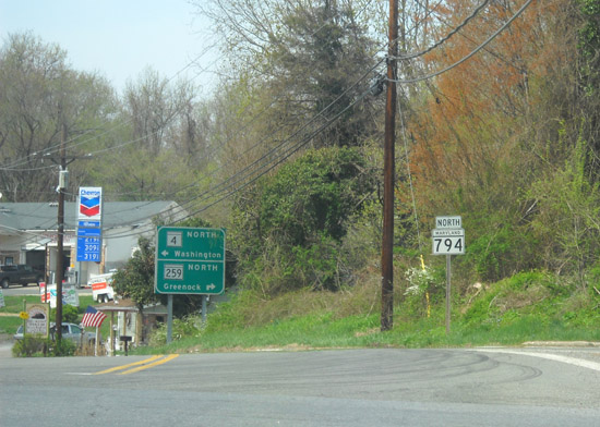
MD 794
· Southern Maryland Blvd
2.75 mi.; from MD 408 southeast to ramps of MD 4/258.
Status: Signed north-south, but in only one place. An original piece of Southern Maryland Blvd, which was first numbered 416 before becoming MD 4. Now parallels the current 4 on the east side; the western parallel frontage is MD 980.
|
794
2.8 MD 4080.5 MD 259 0.4 MD 796 0.3 MD 258 0.0 MD 4 |
|
Baltimore
Reisterstown
|
MD 795 (Reisterstown)
· [no name]
0.47 mi.; from I-795 end ramp at MD 140 northeast to MD 30/MD 128 intersection.
Status: Unsigned, associated with I-795. NHS: Entire length. MD 795 has no signage, no official name, but is in the NHS, serving to funnel traffic between the MD 30 corridor through Hampstead, Manchester and Hanover, PA to I-795. It could pass as a western extension of MD 128, which ends directly across MD 30 from it. A second instance of MD 795, without even a suffix to separate them, the other 795 is so obscure nobody would be confused. |
|
|
Dorchester
Cambridge
|
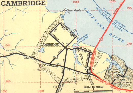
MD 795 (Cambridge)
· Maryland Ave [Cambridge]
0.07 mi.; Bridge over Cambridge Creek (Structure #9008) .
Status: Unsigned, associated with MD 343. This MD 795 is the original to hold the number, assigned in 1955, after MD 343 was rerouted southward. It consists only of the bridge over Cambridge Creek. MD 551 and MD 744 are no more.
|
|
|
Anne Arundel
Bristol
|
MD 796
2 sections
Status: Unsigned, associated with MD 258. No sign of this route, in terms of signage or name. Seem to be old alignments of MD 258, and may possibly be gravel. Sections of MD 796: |
|
|
Anne Arundel
Annapolis
|
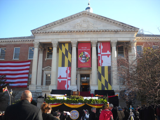
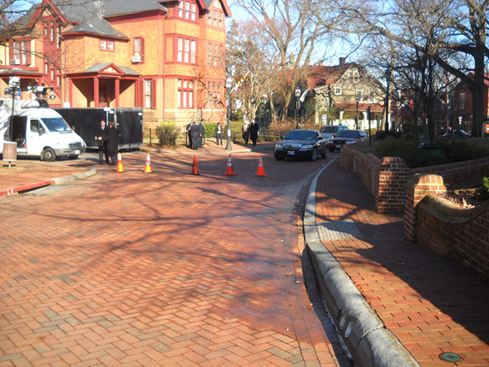
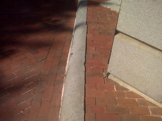
MD 797
· State Circle
0.27 mi.; circle around Maryland State House.
Status: Unsigned. Encircles the Maryland State House, the oldest state capitol building in continuous usage, serving for a short time (1783-84) as the nation's capital. The State House is not in the center of the circle, and comes within inches of touching at the northwest corner. The only state route to consist entirely of a circle, and the only state route paved entirely with brick. MD 797 is also a floating route, as no connecting street is officially a route. The closest candidate would be School Street, a short connector to Church Circle, which is part of MD 450.
|
|
|
Anne Arundel
Crownsville
|
MD 798
· Old Generals Hwy
0.34 mi.; from Sherwood Forest Rd north to MD 178.
Status: Unsigned, associated with MD 178. Part of Old MD 178, the southern part of which was transferred back to county maintenance. |
|
|
|
MD 799
not assigned
|
|