
|
| Routes: Interstates US Routes State Routes: | Home |
| Routes 840-859 (820-839) Prev (860-879) Next |
Quick Links: Marked Unmarked
Decommissioned |
|
Talbot
McDaniel
Sherwood |
MD 840
3 sections
No longer assigned (decommissioned 1998). Sections of MD 840: MD 840A: (no name) 0.26 mi.; from MD 33 east to road end. |
|
|
Talbot
Bozman
|
MD 841
· was May Port Rd.
0.17 mi.; from MD 579 south to end of state maintenance.
No longer assigned (decommissioned 1998). The former MD 841 is a driveway-like gravel road extending south off MD 579. There are gates at the end where the road splits into private driveways. |
|
|
|
MD 842
Not assigned. |
|
|
Washington
Williamsport
Huyett |
MD 843
4 remaining sections.
Unmarked, associated with MD 63. Sections of MD 843: MD 843B: Celeste Dr. 0.12 mi.; from unnamed road and end of state maintenance. Parallels MD 63 north of Williamsport. |
|
|
Washington
Cavetown
|
MD 844
· Cavetown Church Rd.
0.29 mi.; from MD 64 east to road end.
Unmarked, associated with MD 64. |
|
|
Washington
Keedysville
|
MD 845
· Main St [Keedysville]
1.23 mi.; loop south of MD 34.
Unmarked, officially 845A, associated with MD 34. Part of the old 34 before being routed around Keedysville. |
|
|
Washington
Ringgold
|
MD 846
2 pieces.
Unmarked. Sections of MD 846: South of MD 418 just east of MD 64 in Ringgold. MD 846B: (no name) 0.10 mi.; Two dead ends, with access to MD 418 via 846D. |
|
|
Washington |
MD 847
· Fritz La.
0.14 mi.; from Welty Church Rd north to road end.
Unmarked, officially 847D. Parallels east side of MD 64 between Ringgold and Smithsburg. |
|
|
|
MD 848
Not assigned. |
|
|
Carroll
Mexico
|
MD 849
· Leisters Church Rd.
0.36 mi.; between MD 852 and MD 482.
Unmarked. MD 849 is a small part of what was MD 87 extending southward from 482. |
|
|
Frederick
Frederick
Carroll
Taylorsville
Winfield Eldersburg Oakland Baltimore
Harrisonville
|
MD 850
· Old Liberty Rd.
9 pieces.
Unmarked, associated with MD 26. MD 850 is assigned to the many old alignments of MD 26, mostly across Carroll County. Not all such sections remain under state maintenance, such as a small piece of old alignment just across Liberty Reservoir on the Baltimore County side. Sections of MD 850: 850 G, I, and J are north of 26, all others south. |
|
|
Carroll
Sykesville
Howard
|
MD 851
8 sections
Unmarked, associated with MD 32. Sections of MD 851: Except for the main 851, the suffixed sections run north to south down MD 32. MD 851, 851A, B, C are west of 32, others east. |
|
|
Carroll
New Windsor
Westminster Manchester |
MD 852
12 sections.
One section marked, the rest unmarked, associated with the old extent of MD 31, which included current 27 northeast of Westminster.
Sections of MD 852: |
|
|
Carroll
Taneytown
|
MD 853
4 sections.
Unmarked, parts of old MD 194 (old number 71). Sections of MD 853: All north of Taneytown. |
|
|
Carroll
Fenby
Eldersburg |
MD 854
2 sections.
Unmarked, associated with west side of MD 97, between Routes 26 and 32. Sections of MD 854: |
|
|
Kent
Kennedyville
|
MD 855
· (no name)
0.07 mi.; loop off MD 213.
Unmarked, officially 855A. MD 855 is what was a sharp curve on old 213. |
|
|
Kent
Lynch
|
MD 856
· Old Lynch Rd.
0.10 mi.; loop off MD 298 (Lamb Meadow Rd.)
Unmarked. Part of the old MD 298, 856 features the narrow concrete slab common on old routes in Kent County, as seen in the pics below. As can also be seen, it's marginally passable and the asphalt shoulders are overgrown with grass. 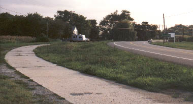 MD 856 alongside MD 298, looking south toward MD 561, 1998. Route 561 is a left turn just past the house.
 |
|
|
|
MD 857
Not assigned. |
|
|
Washington
Rohrersville
Gapland |
MD 858
4 sections.
Unmarked, parts of old MD 67. Sections of MD 858: |
|
|
Kent
Chestertown
|
MD 859
· was Hadaway Dr.
east off MD 213 to 291?
No longer assigned (decommissioned 199x). |


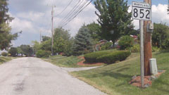 MD 852 marker (photo 07-18-09).


