
|
| Routes: State Routes: Interstates US Routes | Home |
| Routes 12-21 (7-11) Prev (22-39) Next |
Quick Links: Marked Unmarked
Decommissioned |
|
Wicomico
Salisbury
Worcester Longridge
Snow Hill Girdletree Stockton |
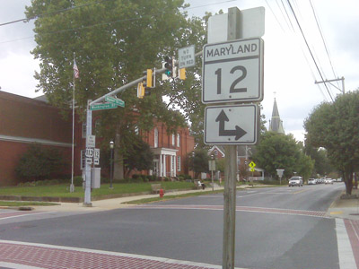
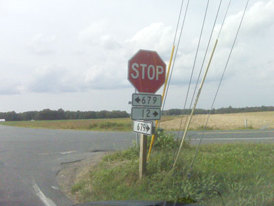
MD 12
· Snow Hill Rd.
30.63 mi.; from Main St. in Salisbury southeast to Virginia line
Status: Marked north-south. Starting out among the streets of Salisbury, still at Main Street (old US 213/50), MD 12 makes a beeline for Snow Hill, where there's a dogleg and short concurrency with Business US 113. At its southern end, 12 is the only state route to cross into Virginia on dry land. Becomes VA Secondary 679 for Accomack County.
|
12
30.6 Main28.0 = US 13 23.4 WO-WI Line 14.0 MD 354 12.7 US 113 Bus.* 12.6 US 113 Bus.* 11.0 US 113 3.3 MD 366 0.0 VA Line 0.0 VA 679 |
|
Worcester
Somerset
Wicomico
|
US 13
· Ocean Hwy, N Salisbury Blvd, Salisbury Bypass, S Fruitland Blvd
42.48 mi. in Maryland; from Virginia line south of Pocomoke City north to Delaware line near Delmar.
Status: Marked north-south. NHS: Entire Length. US 13 has its own page in the US highway section. |
|
|
Dorchester
Secretary
East New Market Rhodesdale Brookview Eldorado |
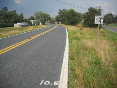
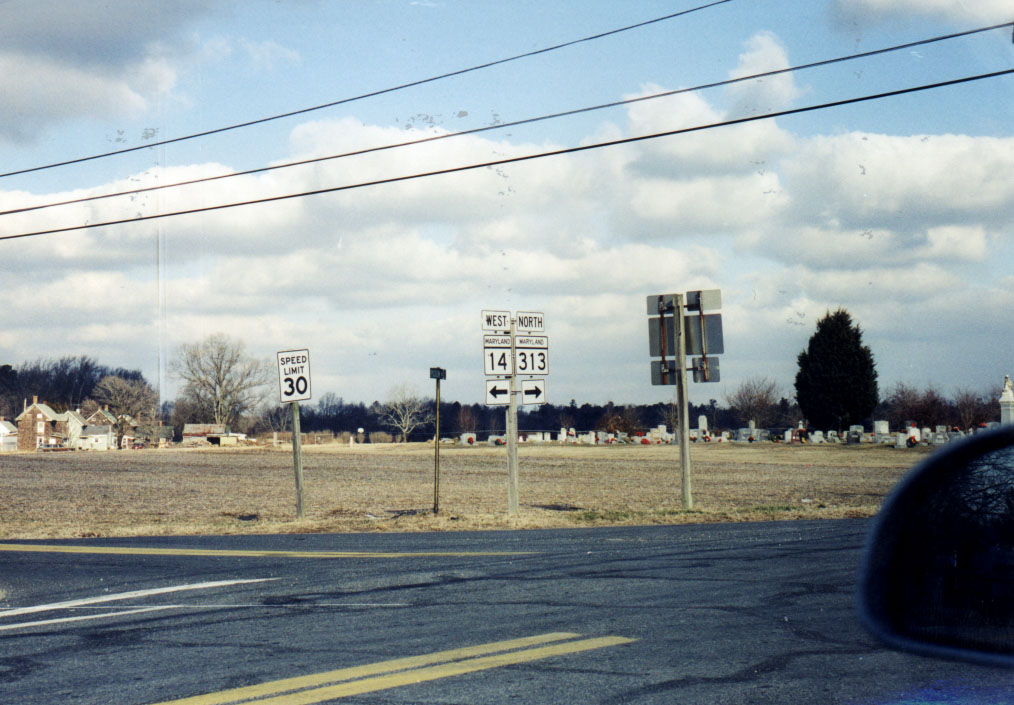
MD 14
11.51 mi.; from MD 16 near Secretary east to MD 313 in Eldorado
Status: Marked east-west. Associated Secret-Obscure Routes: Features a two mile concurrency with MD 331.
|
14
0.0 MD 163.2 MD 16 3.7 MD 392 6.4 MD 331* 8.4 MD 331* 11.5 MD 313 |
|
Frederick
|
US 15
· Catoctin Mountain Hwy.
37.85 mi. in Maryland; from VA line at Point of Rocks
north to PA line north of Emmitsburg
Status: Marked north-south. NHS: Entire Length. Associated Secret-Obscure Routes: US 15 has its own page in the US highway section. |
|
|
Dorchester
Taylors Island
Madison Woolford Church Creek Cambridge East New Market Caroline
Preston
Harmony Potters Ldg. Andersontown |
MD 16
51.06 mi.; from Taylors Island bridge east to Delaware
line southeast of Denton
Status: Marked east-west. Associated Secret-Obscure Routes: |
16
0.0 BSM9.6 MD 335 14.6 MD 341 16.9 US 50* 19.6 US 50* 23.5 MD 14 24.4 MD 392 25.2 MD 14 29.2 MD 331* 32.6 DO-CL Line 32.7 MD 817 33.1 MD 817 33.7 MD 324 38.9 MD 578 43.1 MD 617 45.4 MD 404* 45.4 MD 313* 45.9 MD 313* 48.6 MD 404* 51.1 DE Line 51.1 DE 16 |
|
Frederick
Brunswick Rosemont Burkittsville Middletown Myersville Ellerton Wolfsville |
MD 17
29.49 mi.; from Potomac River bridge in Brunswick to
Frederick-Washington Co. line, South Mtn.
Status: Marked north-south. This route was originally MD 33 until 1940. Route 17 was broken in two when the section between I-70 and US 40 was turned over to county maintenance. The remaining part of 17 north of 40 became MD 153. The middle section was later returned to the state, and 17 was restored to its original length. |
17
29.5 ESM29.5 FR-WA Line 19.5 US 40 18.3 I-70 42 13.0 US 40 Alt 9.5 MD 383 2.7 US 340 2 2.6 MD 180 2.3 MD 871 1.5 MD 464 1.5 MD 79 0.1 VA Line 0.0 VA 287 |
|
Talbot
Easton
St. Michaels Claiborne |
MD 17
old number for current MD 33.
Status: Now part of MD 33.
|
|
|
Queen Anne's
Love Point
Stevensville Chester Grasonville Centreville |
MD 18
· Love Point Rd., Main St.
20.47 mi.; from Love Point east to Centreville in 2
main pieces
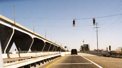
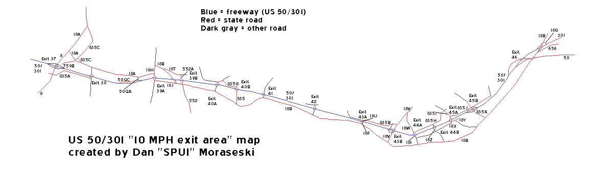
Status: Marked east-west. Associated Secret-Obscure Routes: 456 656 759 835 835A Once the only road to Kent Island, it's still the main drag for locals trying to avoid Bay Bridge traffic. The original 18 stops and starts, as it has to hop one side or the other of 50-301. The traffic problem was helped when the new Kent Narrows bridge was built for 50-301, and the old drawbridge span was handed down to 18. Sections of MD 18:
18A, 18B, and short piece of 18H are mainline segments signed as 18.
Dan Moraseski clears the air with his map of
the MD 18/US 50-301 corridor, the 'land of the 10 mph ramps', from the
Bay Bridge east to the 50-301 split.
|
18
0.0 BSM3.6 MD 8 6.0 MD 552 7.5 US 50-301eb 41 13.3 US 50 (No access across US 50.) 13.4 US 50 13.6 MD 656 13.7 US 301 14.2 MD 456 20.5 MD 213 |
|
Queen Anne's
Church Hill
Roberts Ingleside |
MD 19
· N Main St [Church Hill], Walnut St [Church Hill], Roberts Station Rd.
8.60 mi; from MD 213 in Church Hill east to MD 313 in Ingleside
Status: Marked east-west. Suffixed sections of MD 19: |
19
0.0 MD 2130.5 MD 300 1.1 MD 19a 2.1 MD 405 3.9 US 301 8.6 MD 313 |
|
Kent
Gratitude
Rock Hall Edesville Sandy Bottom Chestertown |
MD 20 (east)
· Rock Hall Rd.
13.74 mi.; from Beach Rd. in Gratitude east to MD 291, Chestertown
Status: Marked north-south. Associated Secret-Obscure Routes: The eastern of the two MD 20s, and the one which makes more sense in the old numbering system. |
20
0.0 road end1.4 MD 445 1.9 MD 674 2.0 MD 288 6.6 MD 21 7.9 MD 298 11.6 MD 446 13.6 MD 514 13.7 MD 291 |
|
Baltimore
Eastpoint
Edgemere |
MD 20 (west)
· was (Old) North Point Rd.
4 pieces; from near Baltimore City line to MD 718, Edgemere
Status: Decommissioned 1999. Associated Secret-Obscure Routes: Unsure why two MD 20s, but many have thought a ferry once ran between them. There was, from the end of this 20, but to the end of 21 on the Eastern Shore at Tolchester Beach, then a popular resort. North Point Road was the path of the attempted British march on Baltimore during the War of 1812, to which several monuments along the road attest. Before World War II, MD 20 was the main road down the Patapsco River Neck. MD 151 consisted of the current 718 and current 151 west to the Sparrows Point steel mill. Wartime truck traffic necessitated a 4-lane divided replacement for MD 20 from US 40 down to the mills. In 1942 the new North Point Blvd. was opened and designated MD 151, which overlaid the old 20. MD 20 is now one of those routes that seem to dart from side to side along the way, like 7, 144, and 18. Speaking of 18, there's a break in 20 where it runs smack into the outer ramps of the MD 150-151 cloverleaf. The northern terminus is at a dead end near the city line. Technically 20 also applies to the piece of North Point Rd. inside Baltimore City, but it's never been marked in recent memory, and contains a one-lane railroad underpass. The southern terminus was at an indeterminate point where a railroad once crossed it south of Edgemere, but has been rolled back to the MD 718 junction in Edgemere, forming an L-shaped junction. Sections of MD 20: Running
north to south, 20 A-D are mainline. |
|
|
Kent
Sandy Bottom
Tolchester Beach |
MD 21
· Tolchester Beach Rd.
2.42 mi.; from eastern MD 20 west to MD 445.
Status: Marked east-west. Western end has been rolled back to MD 445; it had ended at a boat ramp on the Chesapeake Bay at Tolchester Beach, once a popular amusement park in the twenties and thirties. A ferry once shuttled passengers from Baltimore to the park, and this route. It was to be the eastern end of a proposed northern Bay Bridge which never came to fruition. |
21
0.0 MD 4452.4 MD 20 |


