
|
|
Home | Interstates | US Routes | MD Routes | Road Pics | About | Links |
| Routes 300-319 (280-299) Prev (320-339) Next |
Quick Links: Marked Unmarked
Decommissioned |
|
Queen Anne's
Church Hill
Dudley Cor. Sudlersville |
MD 300
· Sudlersville Rd, Main St [Sudlersville]
13.55 mi.; from MD 213 in Church Hill east to
Delaware border
Marked east-west. NHS: east of US 301 to Delaware border. ................... |
300
0.0 MD 2130.2 MD 19 3.9 US 301 5.5 MD 290 7.3 MD 837 7.4 MD 313 13.6 DE Line 13.6 DE 300 |
|
Cecil
Kent
Queen Anne's
Anne Arundel
Prince George's
Charles
|
US 301
· Blue Star Mem. Hwy.
122.85 mi. in Maryland; from Virginia line at Harry W. Nice Bridge northeast
to Delaware line near Middletown.
Marked north-south. US 301 has its own page in the US highway section. |
|
|
Queen Anne's
Crumpton
Pondtown Dudley Cor. |
MD 301
· was Dudley Corners Rd, Crumpton Rd
old number for southern segment of MD 290.
No longer assigned (decommissioned 1940), entire route now part of MD 290. MD 301 was made part of MD 290 when US 301 arrived in Maryland in 1940. Unlike Interstate/Maryland number conflicts, US and Maryland number duplication was frowned upon in that bygone era. By coincidence, US 301 happened to be rerouted to a path crossing the original MD 301 around 1960. US 301 ended in Baltimore from 1940-60, and Eastern Shore US 301 was MD 71 after being built in the late 1950s. |
|
|
Queen Anne's
Barclay
Templeville Caroline
Templeville
|
MD 302
· Barclay Rd, Church St [Barclay]
10.21 mi.; from US 301 east to DE border.
Marked east-west. East of Woodyard Rd, MD 302 forms the line between Queen Anne's and Caroline Counties. This line-forming part of 302 was numbered MD 492 until sometime before 1948. |
302
0.0 US 3013.5 MD 313 7.7 QA-CL Line 9.1 MD 454 10.2 DE Line 10.2 DE 11 |
|
Talbot
Queen Anne
Tappers Cor. |
MD 303
· Tappers Corner Rd, Lewistown Rd, Main St [Queen Anne]
4.20 mi.; from Alt MD 404 in Queen Anne south to
MD 303
Marked north-south. At one time, 303 extended north along current MD 309 in Queen Anne's County to 213. What remoains of 303 today appears to be an insignificant loop in northeastern Talbot County. The current section was also once called Old Cordova Rd. |
303
4.2 MD 4044.0 MD 309 3.8 TA-QA Line 3.7 MD 404 Alt* 3.6 MD 404 Alt* 0.0 MD 309 |
|
Queen Anne's
Centreville
Ruthsburg Caroline
Bridgetown
|
MD 304
· Corsica Neck Rd, Bridge St [Centrevlle], Chesterfield Ave [Centreville], Water St [Centreville], Railroad Ave [Centreville], Ruthsburg Rd, Bridgetown Rd
15.23 mi.; from end of state maintenance
at Spider Web Rd east to MD 312.
Marked east-west. Between 1948 and 1953, there was a break in maintenance west of Centreville, the noncontiguous, 'floating' part of Corsica Neck Rd remaining to the west was numbered MD 606. |
304
0.0 Begin3.3 MD 213 5.8 US 301 10.0 MD 481 13.9 MD 405 15.2 MD 312 |
|
Queen Anne's
Centreville
Carville Hope Roe Ingleside |
MD 305
· Hope Rd
5.08 mi.; from US 301 in Centreville east to
end of state maintenance at Dean Rd/Hayden Clark Rd.
Marked east-west. ................... |
305
0.0 MD 2132.9 US 301 5.1 ESM |
|
Caroline
Federalsburg
|
MD 306
· Houston Branch Rd
4.13 mi.; from eastern limits of Federalsburg northeast to
Delaware line
Status: Marked east-west. A floating route because it doesn't go into Federalsburg. |
306
0.0 Begin4.1 DE Line 4.1 DE RD 31 |
|
Dorchester
Hurlock
Williamsburg Caroline
Federalsburg
|
MD 307
· Broad St [Hurlock], Williamsburg Rd, Academy Ave [Federalsburg]
6.05 mi.; from MD 331/North Main St in Hurlock northeast to end of state maintenance at Charles St, Federalsburg.
Marked east-west. Unsure if the official route continues past Charles Street on Academy Avenue to Main Street. The marker at Charles Street is the only one in Federalsburg on any route. Learning bad habits from Baltimore. |
307
0.0 MD 3315.7 MD 313 6.1 End |
|
Caroline
Federalsburg
|
MD 308
· S Main St [Federalsburg]
0.12 mi.; from MD 313/318 north to southern limits
of Federalsburg.
Unmarked. Not surprised it's unsigned, as it's only ~600 feet long. In case signage is added later, I've left the mileage table on. |
308
0.1 0 End0.0 0 MD 313 |
|
Queen Anne's
Starr
Talbot
Queen Anne
Cordova |
MD 309
· Starr Rd, Cordova Rd, Black Dog
Alley
18.50 mi.; from US 50 north to MD 213.
Marked north-south. Most of the Queen Anne's County segment was originally MD 303. A new type of road striping is being tried in the small hamlet of Starr, with a small median and painted brick on the sides to simulate a town road, as an attempt to get drivers to slow a bit. I need to get a photo of this. It's similar to some of the painted brick crosswalks I've seen in various Eastern Shore towns. The southernmost tip of MD 309 was run along Black Dog Alley to form a T intersection with US 50 north of Easton. It also aligns with a new section of MD 662 directly across. This improves access to/from Easton for locals not using US 50. |
309
18.5 MD 21311.8 MD 481 9.7 MD 404 9.6 MD 303 9.2 MD 404 Alt 6.7 MD 303 0.0 US 50 |
|
Cecil
Cayots
St Augustine |
MD 310
· Cayots Corner Rd
3.96 mi.; from MD 213 east to Del. state
line.
Marked east-west. ................... |
310
0.0 MD 2132.2 MD 342 4.0 DE Line 4.0 DE RD 432 |
|
Caroline
Marydel
Henderson Goldsboro |
MD 311
· Halltown Rd, Henderson Rd, Main St [Goldsboro]
6.11 mi.; from MD 313, Goldsboro northeast to MD 454, Marydel.
Marked north-south. MD 311 ends at MD 454 in Marydel, near the state line, but it's 454 that crosses the line. |
311
6.1 MD 4546.0 MD 821 0.3 MD 287 0.0 MD 313 |
|
Caroline
Baltimore Cor.
Oakland Ridgely |
MD 312
· Central Ave [Ridgely], Downes Station Rd, Oakland Rd
11.41 mi.; from MD 313 to MD 404.
Marked north-south. ................... Associated Secret-Obscure Routes: 776 |
312
11.4 MD 3139.1 MD 304 2.7 MD 776 2.3 MD 480* 1.4 MD 480* 0.0 MD 404 |
|
Kent
Galena
Massey Millington Queen Anne's
Unicorn
Sudlersville Barclay Ingleside Caroline
Baltimore Cor.
Goldsboro Greensboro Denton Andersontown Concord Federalsburg Dorchester
Finchville
Eldorado Wicomico
Sharptown
Mardela Springs |
MD 313
· Delmar Rd, Sharptown Rd, Eldorado Rd, Reliance Rd, Federalsburg Hwy, Shore Hwy, Greensboro Rd, Old Town Rd [Goldsboro], Goldsboro Rd, Church St [Sudlersville], Millington Rd, Sassafras St [Millington], Millington-Massey Rd, Massey-Galena Rd, S Main St [Galena]
75.72 mi.; from US 50, Mardela Springs north to
US 301, Galena.
Marked north-south. At over 75 miles, MD 313 is the second longest state route, and 9th longest overall, tracing a long path down the inland portions of the Eastern Shore. The number has been the same as long as there has been numbering, which begs the question if it was ever a US route. As far as can be told my answer would be no, but it was certainly a candidate for US highway status. The intersection with US 301 has been reconfigured. There is no direct access to cross 301 anymore; one has to turn right on 301 and use a U-turn lane provided a short distance away, then swing back for a right turn to continue on 313. Associated Secret-Obscure Routes: 820 837 |
313
75.7 MD 21375.7 MD 290* 75.0 MD 290* 73.2 US 301 71.7 MD 299 71.7 MD 330 67.9 QA-KE Line 65.6 MD 544 61.8 MD 837 61.7 MD 300 58.7 MD 302 55.0 MD 19 52.3 MD 312 50.1 MD 820 48.8 MD 287 48.4 MD 311 44.9 MD 480 44.0 MD 314 38.9 MD 317 38.1 MD 404* 38.1 MD 619 32.2 MD 404* 22.3 MD 318 22.3 MD 315 21.9 MD 307 20.6 MD 308 20.1 MD 318 18.9 MD 577 15.6 MD 392 12.2 MD 14 6.1 MD 348 5.6 MD 813 0.1 MD 54 0.0 US 50 |
|
Caroline
Greensboro
Whiteleysburg |
MD 314
· Sunset Ave [Greensboro], Whiteleysburg Rd, Two State Rd
4.93 mi.; from railroad crossing at west end of Greensboro east to Delaware state line.
Marked east-west.
In Greensboro, the portion of 314 from 480 west to the railroad tracks was once MD 315. A new Choptank bridge for MD 314 was completed in 1995; this section, E Sunset Ave, along with N Main, was part of MD 313. Two State Road, now a small spur near the state line in Whiteleysburg (MD 314A) was the original 314 which connected to DE 12. The small piece of Whiteleysburg Rd from Two State Road to the line was numbered MD 489. You now have to make a left to end up on DE 12; going straight on Whiteleysburg Rd ends up being DE Road 59 (the secondary designation). DE 12 may still run along Two State Rd and connect to MD 314A, and although signed as DE 12, Burnite Mill Rd also carries DE Road 452. All Delaware routes, even if a signed primary route, also carry the secondary DE Road numbers. The primary route just overlays. The pavement quality east of 313 is excellent. In Greensboro it's a bit rough and shows some cracks, but that's how I can tell if it was a state route; that's from the original pavement beneath. |
314
0.0 Begin0.6 MD 480 1.0 MD 313 4.8 MD 314A 4.9 DE Line 4.9 RD 59 4.9 DE 12 |
|
Caroline
Federalsburg
|
MD 315
· Bloomingdale Ave, N Main St [Federalsburg], E Central Ave [Federalsburg], Liberty Rd
3.13 mi.; from MD 313 east to MD 318
Signed north-south east of Federalsburg town limits. Runs through the town of Federalsburg, which is bypassed by MD 313 and 318. Although an east-west route, it is signed north-south. The only signed junction is at MD 318 east of Federalsburg, 318 being longer and signed east-west, so I suppose it was signed north-south to contrast and be 'perpendicular' with 318. There is a reference to the bridge over Marshyhope Creek in Federalsburg as being part of MD 315, but all signage stops at the town limits. No signage for 315 appears at the supposed western end along MD 313. |
315
0.0 MD 3130.0 MD 318 1.0 Main St 1.0 E Central Ave 3.1 MD 318 |
|
Caroline
Greensboro
|
MD 315
· was Sunset Ave [Greensboro]
from railroad crossing at west end of Greensboro east to Main St (MD 480).
Route annexed by MD 314, number later reassigned.
The portion of 314 from 480 west to the railroad tracks was once MD 315. This was likely before MD 313 was completed northeast of town, and 313 ran along E Sunset Ave and N Main St. Therefore, separate numbers in the no dual-number policy. |
|
|
Cecil
Elk Mills Elkton |
MD 316
· Appleton Rd
2.67 mi.; from MD 279 to MD 277.
Marked north-south. Number seems out of place for Cecil County; its nearby numbers being further down the shore. Overpasses I-95 with no direct access. |
316
2.6 MD 2770.0 MD 279 |
|
Caroline
Denton
Burrsville |
MD 317
· Burrsville Rd
4.78 mi.; from MD 313 east to DE border.
Marked east-west. Runs east from 313 north of Denton to the border. Becomes DE 14 on the other side. |
317
0.0 MD 3134.8 DE Line 4.8 DE 14 |
|
Dorchester
Elwood
Caroline
Federalsburg
|
MD 318
· Preston Rd, Federalsburg Hwy, Bridgeville Rd
11.32 mi.; from MD 331 near Elwood east to DE line east of Federalsburg.
Marked north-south. Between Elwood and Federalsburg, this route is the county line between Dorchester and Caroline. This section was also once numbered MD 319. MD 313 & 318 are co-signed along the bypass south and west of Federalsburg. MD 318 becomes DE 18 at the border. ................... |
318
0.0 MD 3310.4 MD 817 5.7 MD 313* 5.7 MD 315 7.8 MD 313* 9.9 MD 315 11.3 DE Line 11.3 DE 18 |
|
Dorchester
Elwood
Caroline
Federalsburg
|
MD 319
· was Preston Rd
from MD 331 east to MD 313.
No longer assigned (decommissioned), entire route now part of MD 318. ................... |


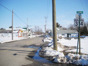 Western beginning of MD 314, Greensboro. (photo 02/21/10)

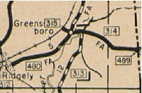 The separate MD 315 in Greensboro, from the 1939 official SRC map.


