
|
| Routes: Interstates US Routes State Routes: | Home |
| Routes 560-579 (540-559) Prev (580-599) Next |
Quick Links: Marked Unmarked
Decommissioned |
|
Garrett
Mountain Lake Park
Loch Lynn Heights Kearney Gorman |
MD 560
· Gorman Rd, Lothian St (Loch Lynn Heights), Third Ave (Loch Lynn Heights), Paul St (Loch Lynn Heights, Mountain Lake Park)
9.32 mi.; from WV Border north to MD 135, Mountain Lake Park.
Marked north-south. ................... |
560
9.3 MD 1350.0 US 50 |
|
Kent
Lynch
|
MD 561
· Hassenger's Corner Rd
2.48 mi.; from MD 213 north to 298
Marked north-south. ................... |
561
2.5 MD 1350.0 US 50 |
|
Baltimore
Shepperd
Monkton |
MD 562
· Troyer Rd., Old York Rd.
1.39 mi.; from MD 138 south to end of state maintenance
at Markoe Rd.
Marked north-south. Along with MD 439, another numbered portion of Old York Rd. |
562
1.4 MD 1380.0 Markoe Rd. |
|
Charles
Riverside
|
MD 563
· was Riverside Rd
old number for current MD 224 south of MD 344
No longer assigned (decommissioned), entire route now part of MD 224. ................... |
|
|
Prince George's
Lanham
Glenn Dale Bowie |
MD 564
· Lanham-Severn Rd, 9th St (Bowie), Chestnut Ave (Bowie), 11th St (Bowie), Race Track Rd
6.73 mi.; from MD 450, Lanham east to MD 197, Bowie.
Marked east-west. Once ended at olf MD 197 in Bowie, but extended east to new 197 along Race Track Rd. Circa 1957, this route was called Lanham-Bowie Rd. Sections of MD 564: |
564
0.0 MD 4502.9 MD 953A 3.0 MD 193 5.6 MD 564A 5.7 MD 564C 6.7 MD 197 |
|
Talbot
Easton
Stumptown Trappe |
MD 565
· Easton-Trappe Rd, Main St (Trappe), S Washington St (Easton)
from Maple Ave, Trappe north. to Lee Terrace, Easton in 3 sections.
Marked north-south.
MD 565 is a catch-all number for old 50 south of Easton, much the same way as MD 662 to the north. At one time encompassed all of Washington St in Easton, but now only consists of a small stub off of MD 322. Mileage table is from north to south, though this means the suffixed 565A goes first. Sections of MD 565: |
565 (a)
0.6 Lee Terrace0.0 MD 322 565
5.1 US 505.0 MD 565B 0.0 Maple Ave |
|
Kent
Still Pond
|
MD 566
· Stillpond-Harmony Rd
1.19 mi.; from MD 292 east to MD 298.
Marked east-west. ................... |
566
0.0 MD 2921.2 MD 298 |
|
Baltimore
Towson
|
MD 567
· was Cromwell Bridge Rd
from beginning of state maintenance east to Manor Rd.
No longer assigned (decommissioned 1999). This was a 'floating' route, never touching any other route. It never did extend west to I-695 Exit 29, but instead ended further east at an indeterminate point. MD 567 was likely dropped in 1999 along with MD 20 and MD 718, in exchange for the addition of Merritt Blvd to SHA maintenance as MD 157.
|
|
|
Worcester
Bishopville
|
MD 568
· Hatchery Rd
0.41 mi.; from MD 367 north to Delaware border.
Status: Signed north-south. Finally signed in 2011, after having been in the system as far back as maps depict (1927), probably as part of MD 368, which appears on the first detailed map of 1938. MD 568 was first used for the part of current 367 east of it. The current arrangement of routes first appears on the 1950 official map, but this may have been due to the new map style that year. Becomes Delaware Road 397 at the border. |
568
0.4 RD 3970.4 DE Line 0.0 MD 367 |
|
Carroll
Westminster
|
MD 569
· was Bachman Valley Rd
from MD 97 northeast to end of state maintenance.
No longer assigned (decommissioned). ...................
|
|
|
Baltimore
Woodlawn
|
MD 570
2.74 mi.; stub end of I-70, from I-695 east to Park & Ride
Removal of Interstate status approved by AASHTO 2014, new state number proposed 2020. MD 570 will be the new designation for the stub end of I-70 inside the I-695 Beltway to the Park & Ride at the city line. Planned to be used as a route for the cancelled Baltimore Red Line, it remains as a half-abandoned relic, used for emergency exercises. |
|
|
Carroll
Westminster
Fenby Barrett |
MD 570
· was Old Washington Rd, O'Brecht Rd
old number for part of MD 97
No longer assigned (decommissioned). MD 570 consisted of some bits and pieces of road in southern Carroll County. By 1958, 570 became a section of the 2-part MD 97, which was subsequently linked.
|
|
|
Frederick
Emmitsburg
|
MD 571
· was Tracet Rd
north off US 15 to Pennsylvania line.
No longer assigned (decommissioned). MD 571 dated as far back as 1937.
|
|
|
Washington
Gapland
|
MD 572
· was Gapland Rd
from MD 67 east to Washington-Frederick County line.
Unmarked Ends at Crampton's Gap, along the ridgetop of South Mountain and the Appalachian Trail. This was also the site of the first major fighting in the Civil War in Maryland, on September 14, 1862. At the ridgetop is a monument to Civil War correspondents. |
|
|
Carroll
Eldersburg
|
MD 573
· was Bartholow Rd
from approx. Collins Ave north to indeterminate point.
No longer assigned (decommissioned). ...................
|
|
|
St. Mary's
Clark's Landing
|
MD 574
· was Clark's Landing Rd
northeast off MD 235 to road end.
No longer assigned (decommissioned 1970s). ................... |
|
|
Worcester
Jones
|
MD 575
· Worcester Hwy
2.70 mi.; from US 113 northeast to MD 589.
Marked east-west. A recently bypassed part of old US 113. |
575
0.0 US 1130.8 MD 452 1.7 - MD 90 2.7 MD 589 |
|
Calvert
Huntingtown
Willows |
MD 575
· was Pond Woods Rd
~1.2 mi. (1937); east off MD 2-4 to end of state maintenance near Spears Rd.
No longer assigned (decommissioned), number re-used for MD 575 above.
|
|
|
Worcester
Pocomoke City
|
MD 576
· was Dunn Swamp Rd, Colona Rd
south off former MD 371
No longer assigned (decommissioned). ...................
|
|
|
Caroline
Federalsburg
Dorchester
Reliance
|
MD 577
· Reliance Rd
3.70 mi.; from MD 392 / DE 20 junction, Reliance northwest to MD 313, Federalsburg.
Marked north-south. MD 577 forms the line between Dorchester and Carolina Counties. |
577
3.7 MD 3130.0 MD 392 |
|
Caroline
Bethlehem
Harmony |
MD 578
· Harmony Rd
4.24 mi.; from MD 331 east to MD 16.
Marked east-west. ................... |
578
0.0 MD 3314.2 MD 16 |
|
Talbot
Bozman
Neavitt |
MD 579
· Bozman-Neavitt Rd.
7.84 mi.; from MD 33 south to road end at Neavitt.
Marked north-south. Associated Secret-Obscure Routes: 841. |
579
7.8 MD 330.0 BSM |


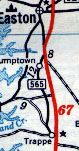 MD 565 shown on a 1958 map.


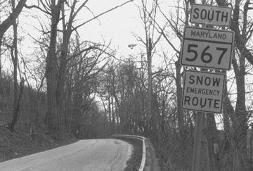 MD 567, facing west (signed southbound), just past Satyr Hill Rd, 1998. It would be decommissioned within a year.


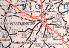 Westminster area routes, including MD 569 (upper right), shown on a 1955 SRC map.

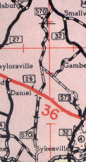 MD 570, shown on the 1948 SRC map.

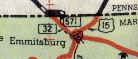 MD 571, shown on the 1948 SRC map.


 MD 573, shown on the 1948 SRC map.


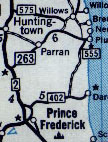 MD 575 (top), shown on a 1958 map.

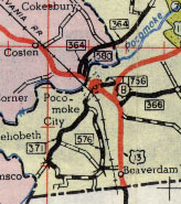 MD 576, shown on the 1948 SRC map.


