|
| Routes: Interstates US Routes State Routes: | Home |
| Routes 880-899 (860-879) Prev (900-919) Next |
Quick Links: Marked Unmarked
Decommissioned |
|
Frederick
Buckeystown
|
MD 880
· Michaels Mill Rd.
1.17 mi.; from MD 85 east to MD 80.
Unmarked. Possibly a earlier routing of MD 80. It was closed to through traffic, as of 12-27-98. |
|
|
Washington
Williamsport
|
MD 881
· was Kendle Rd.
west off MD 68
No longer assigned (decommissioned 197x). MD 881 is the former alignment of MD 68; it appears on an SHA planning map from 1977.
It now dead ends at railroad tracks; it once connected across the tracks and the current I-81 to
Sunset Ave. in Williamsport. Thanks to Kershner Wyatt for this update: |
|
|
|
MD 882
Not assigned. |
|
|
|
MD 883
Not assigned. |
|
|
|
MD 884
Not assigned. |
|
|
|
MD 885
Not assigned. |
|
|
|
MD 886
Not assigned. |
|
|
Baltimore
Cockeysville
|
MD 887
was near old NCRR underpass on MD 45, Cockeysville
No longer assigned (decommissioned 198x). MD 887 was probably the bridge over the old railroad underpass on MD 45. The railroad line was abandoned in 1972, the underpass was removed in the late eighties and MD 45 widened. |
|
|
|
MD 888
Not assigned. |
|
|
Baltimore
Hereford
|
MD 889
· (no name)
0.10 mi.; north off MD 137 to SHA garage.
Unmarked. MD 889 is the access road to the SHA garage next to I-83 Exit 27. |
|
|
Baltimore
Pikesville
|
MD 890
· was Slade Ave.
west off MD 140 to Milford Mill Metro station
No longer assigned (decommissioned 198x). MD 890 was on the books during construction of the Milford Mill Metro station. Once completed, the number was dropped around 1990. |
|
|
Baltimore
Lansdowne
|
MD 891
· Hollins Ferry Rd.
2.02 mi.; from Hammonds Ferry Rd. west to end of state maintenance.
Unmarked. MD 891 mostly consists of the approaches to I-695 Exit 9. |
|
|
|
MD 892
Not assigned. |
|
|
|
MD 893
Not assigned. |
|
|
Washington
Hancock
|
MD 894
· Limestone Rd.
0.64 mi.; from MD 144/US 522 north to road end.
Unmarked. Parallels the west side of US 522, and may be its only grade intersection in Maryland. |
|
|
|
I-895
· Harbor Tunnel Thruway
14.87 mi.; from I-95 Exit 46 north to I-95 Exit 62.
I-895 has its own page in the Interstate Highways section. (or soon will) |
|
|
Montgomery
White Oak
|
MD 895
· was Lockwood Dr.
0.80 mi.; from US 29 northeast to MD 650.
No longer assigned (decommissioned 1999). This route was once part of US 29 (and MD 27 before 1934) in its old alignment from current 895's eastern terminus north along 650 to Ashton, then east on 108. |
895
0.00 US 290.80 MD 650 |
|
Cecil
|
MD 896
· Mechanicsville Rd.
0.21 mi.; linking Delaware 896 & Pennsylvania 896.
Unmarked as a Maryland route (why bother). Yes...that 896. On its way to Pennsylvania, DE-PA 896 just clips the northeast corner of Maryland, making 896 a three-state route. There's no acknowledgement of having passed through Maryland, just a longer than usual space between the welcome signs for Delaware and Pennsylvania. Maryland's short portion has the same wide shoulders as the adjacent Delaware section, whereas shoulders disappear upon entering Pennsylvania. There's only one intersection with 896 within Maryland, at Little Egypt Rd. This short route was numbered 278 until sometime between 1941 and 1948. Since 896 is marked by both Delaware and Pennsylvania, I'll give it a route log to the right, what little there is. |
896
0.00 DE 8960.00 DE Line 0.21 PA Line 0.21 PA 896 |
|
|
MD 897
Not assigned. |
|
|
Montgomery
Rockville
|
MD 898
· was Old Baltimore Rd.
southeast off MD 28 in vicinity of Rock Creek.
No longer assigned (decommissioned 197x). |
|
|
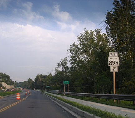
Montgomery
Quince Orchard
|
MD 899
· American Way
2 sections
Southern portion (899A) marked with a "WEST MD 899" turn marker on eastbound MD 28. I had thought this route was unmarked. Thanks to Nick Timrots for this update: Sections of MD 899: The two sections line up with each other one the south side of MD 28.
|
899
0.1 End0.0 MD 28 |