|
| Routes: Interstates US Routes State Routes: | Home |
| Routes 980-999 (960-979) Prev (1-6) Next |
Quick Links: Marked Unmarked
Decommissioned |
|
Prince George's
Upper Marlboro
Anne Arundel
Bristol
|
MD 980
3 main sections
Unmarked, associated with MD 4. For the most part, an unmarked number for sections of frontage roads on the south side of MD 4, the north side frontages bearing route number 794.
Sections of MD 980: A, B, C, D are mainline. |
|
|
Howard
Jonestown
|
MD 981
· Tricross Dr.
0.12 mi.; loop off MD 108
Unmarked. MD 981 is a small loop west of the busy 104-108 junction and their ramps to the new MD 100. |
|
|
Howard
Columbia
|
MD 982
· was Old Columbia Pike
frontage to west of US 29 near MD 103
No longer assigned (decommissioned around 1993). Saw this one on a 1992 planning map. Probably never marked. |
|
|
Howard
Scaggsville
|
MD 983
· Old Scaggsville Rd.
2 sections
Unmarked, associated with MD 216. Number 983 is assigned to the old alignments of MD 216. Realignment was made necessary by construction of the I-95 interchange with 216. The two sections of this route lie on opposite sides of I-95. Sections of MD 983:
MD 983: Old Scaggsville Rd. 1.07 mi.; from Prince George's (Laurel)-Howard County line north to end of state maintenance. Section southeast of I-95. May have extended south into PG County, but bridge is out according to SHA maps.MD 983A: Old Scaggsville Rd. 0.71 mi.; from Leishear Rd. southeast to cul-de-sac. Northwest of I-95, MD 216 is still a broken route; one has to use county-maintained Leishear Rd. to connect with the old and new 216. A study is underway to remedy this. |
|
|
Howard
Ellicott City
|
MD 984
· (service road)
0.22 mi.; from south side of US 40 east to Normandy Dr.
Unmarked. MD 984 is a frontage to the south of US 40, about � mile east of US 29. |
|
|
Howard
Ellicott City
|
MD 985
· Old Frederick Rd., Old Rogers Ave.
2 sections
Unmarked, associated with former MD 99. MD 985 comprises the old Route 99 (it was 105 in this area further back), but this frontage road's designation has outlasted that of the new road that replaced it! East of US 29 (29's northern terminus), Rogers Ave. was stripped of its 99 designation. MD 985 remains in two parts, both just to the north of I-70. Sections of MD 985:
MD 985: Old Frederick Rd. 0.55 mi.; from road end east to Rogers Ave. South of the former 99.MD 985A: Old Frederick Rd., Old Rogers Ave. 0.30 mi.; from Rogers Ave. southeast to road end. East of 99, this section is what remains of the old 99 before I-70 was built nearby. |
|
|
Howard
Columbia
|
MD 986
· South Entrance Rd.
2 remaining sections
Unmarked, associated with US 29. Only the K and L sections of this route remain. A through J were probably scattered all up and down US 29 during its upgrade to limited access. MD 986K: 0.10 mi. (was 0.36 mi.); from US 29 west to end of state maintenance.MD 986L: 0.07 mi.; from US 29 west to end of state maintenance. |
|
|
Howard
Ellicott City
|
MD 987
· was Old Columbia Pike
from US 29 near MD 103 northeast to Main St.
No longer assigned (decommissioned 1995). MD 987 was the pre-freeway US 29, ending at Main St. in Ellicott City, which was then US 40. 29 and 40 continued together east along modern MD 144 into Baltimore. It's an awfully high number, considering it was once a US highway and it's not a frontage, more a spur as it drops steeply into the Patapsco river valley. It may have not been marked for years, but ADC showed 987 at least until 2001. Other commercial maps may still yet show it. The southern end of this former route is now at MD 103, as 987 near the old US 29 junction was removed for an interchange with the new MD 100. |
|
|
Montgomery
N. Chevy Chase
|
MD 988
· was Spring Valley Rd.
0.16 mi.; southwest of MD 185/I-495 interchange.
No longer assigned (decommissioned 1999-officially was MD 988A). Previous Designation: Milton Ave, east off Catherine Ave. south of MD 100. Runs for two blocks parallel to and south of MD 100. Got this one off a Champion wall map, circa 1985. MD 988, 989, and 990 are small stubs to the south of MD 100 in Anne Arundel county. Only 990 is still on the books today. The rest were dropped in the late eighties. |
|
|
Talbot
Trappe
|
MD 989
· Bolingbroke Point Dr..
0.22 mi.; old US 50 northern Choptank Bridge Approach.
Unmarked. MD 989 is the former US 50 approach to the old Choptank River Bridge, of which parts remain as a fishing pier. Previous Designation: Seaborne Dr. northwest from southern end of MD 607. Probably never signed; I never knew this one existed. Provides access to a residential area and a Seventh Day Adventist church, which seems to face MD 607. This road may have had to be reconfigured for improvements to the MD 100-607 grade intersection, i.e. access controls on 607, thus placing Seaborne under SHA maintenance. |
|
|
Anne Arundel
|
MD 990
· (no name)
0.10 mi.; west off MD 177 to Lake Shore Athletic Complex
Unmarked. Access road to undeveloped athletic complex, off 177 just east of MD 100. |
|
|
Wicomico
Salisbury
|
MD 991
· Main St.
0.02 mi.; drawbridge over Wicomico River and approaches.
Unmarked. Main Street in Salisbury was the original route of US 50, and before 1949, US 213. Maintenance of the old route has been turned over to Salisbury except for the drawbridge over the Wicomico River in downtown Salisbury. The last non-bridge part of 991 once stretched 0.70 miles west of the bridge, as the route log begins with that mileage. |
|
|
Wicomico
Pittsville
Worcester
|
MD 992
· John Deere Rd.
7 sections
Unmarked, associated with US 50. The frontage roads that form MD 992 are of much less historical significance than 991. We're back to our plain old service roads here. Sections of MD 992: running west to east. MD 992, 992C, and 992F are north of US 50, all others south. |
|
|
Baltimore
Lansdowne
|
MD 993
· Old Washington Blvd.
0.12 mi.; loop east off US 1 Alt.
Unmarked (officially 993B). This one could fit into a single photo. It's part of the old US 1 before some tight curves were removed. |
|
|
|
MD 994
Not assigned. |
|
|
Anne Arundel
BWI Airport
|
MD 995
· Amtrak Dr.
0.50 mi.; from MD 170 north to BWI Amtrak/MARC Station
Unmarked. NHS: Entire length. (intermodal connector) The access road to the BWI Airport rail station, with a loop and multilevel parking garage at the end. |
|
|
Montgomery
Carderock
|
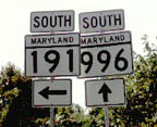
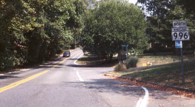
MD 996
· was Eggert Dr.
0.49 mi.; from Persimmon Tree Rd. (then MD 191) to end of state maintenance near Tammy Dr.
No longer assigned (decommissioned 1999). This was the highest number on a route marker in Maryland, and the third highest overall. That distinction is now left to MD 956. Also gone is the section of MD 191 to the east, in a
large clean-up of state routes in Montgomery County.
|
|
|
Anne Arundel
|
MD 997
· (service road)
0.29 mi.; from Morris Tongue Dr. northwest to Jabez Run
Unmarked (officially 997D). The highest route number in Maryland until 2001, 997 (it's actually 997D) passes under I-97, connecting the two sides of old MD 3, just north of I-97 Exit 7. Jabez Run is the name of a small segment of what was the southbound side of MD 3. An unconfirmed instance of 997 is Parallel Dr. south of the Social Security complex in Woodlawn, running alongside the north side of I-70 west off Ingleside Ave. I once saw it in the mid 80s on an old Hearne Brothers wall map, but nowhere else. If only I remembered where this wall map was.... |
|
|
|
MD 998
Not assigned. |
|
|
Anne Arundel
|
MD 999
· Old Hammonds Ferry Rd
0.24 mi.; from Newport Rd/Stewart Ave interection north to cul-de-sac.
Unmarked, officially MD 999D. A new route in 2001, MD 999 takes the highest route number overall. Appears to be south of the intersection of MD 176 and MD 162 southeast of BWI Airport. Previous Usage?The same Hearne Bros. map that shows 997 in Woodlawn also showed a 999 as Old Frederick Rd. in Catonsville. This may be a 'trap' to catch other map publishers in the act of cribbing route numbers off Hearne maps. It's a very curvy road, the original route from the colonial era. It's very unlikely it was ever a state route, but I mention it here in case anyone has seen it elsewhere. |